IMAGES TAKEN NEAR TO
Mill Gate, NEWARK, NG24 4TS
Introduction
This page details the photographs taken nearby to Mill Gate, NG24 4TS by members of the Geograph project.
The Geograph project started in 2005 with the aim of publishing, organising and preserving representative images for every square kilometre of Great Britain, Ireland and the Isle of Man.

There are currently over 7.5m images from over14,400 individuals and you can help contribute to the project by visiting https://www.geograph.org.uk
Image Map
Images are licensed for reuse under creativecommons.org/licenses/by-sa/2.0
Notes
- Clicking on the map will re-center to the selected point.
- The higher the marker number, the further away the image location is from the centre of the postcode.
Image Listing (808 Images Found)
Images are licensed for reuse under creativecommons.org/licenses/by-sa/2.0
Image
Details
Distance
1
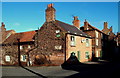
Huddlestone's Wharf/Mill Gate Junction, Newark, Notts.
The high degree of winter-related leaflessness allows a view of some elderly advertising boards on this house at this junction.
Image: © David Hallam-Jones
Taken: 1 Feb 2015
0.01 miles
2
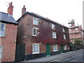
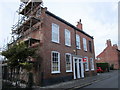
30 and 32 Millgate
Millgate which retains the line of the Roman Fosse Way through Newark was an early suburb of the town, Sadly several notable buildings were demolished during the 1950s and 60s but many still remain. These houses date from the late eighteenth century https://historicengland.org.uk/listing/the-list/list-entry/1278155
Image: © Jonathan Thacker
Taken: 5 Nov 2018
0.01 miles
3
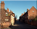
Huddlestone's Wharf/Mill Gate Junction, Newark, Notts.
The view towards the junction with the B6166 (Castle Gate). This street is often used by drivers as a short cut from the side of The Spring House pub - at the western end of Mill Gate, near the marina - to get into the town centre with less queuing on the B6166. The high degree of winter-related leaflessness allows a view of some elderly advertising boards on this house at this junction.
Image: © David Hallam-Jones
Taken: 1 Feb 2015
0.02 miles
4
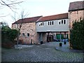
Healy's Wharf
Part of a maze of riverside buildings, beautifully converted into homes. On Newark's historic riverside trail [leaflet available from Newark TIC].
Image: © Christine Johnstone
Taken: 18 Jan 2014
0.02 miles
5
26 and 28 Millgate
Millgate which retains the line of the Roman Fosse Way through Newark was an early suburb of the town, Sadly several notable buildings were demolished during the 1950s and 60s but many still remain. These houses date from the late eighteenth century https://historicengland.org.uk/listing/the-list/list-entry/1231385
Image: © Jonathan Thacker
Taken: 5 Nov 2018
0.02 miles
6
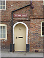
Cottam's Yard
This would have provided access to a narrow yard, not more than about 10 feet wide, with several dwellings giving on to it. Yards like these represented the worst of the slums that mid-20th century slum clearance programmes set out to eradicate. The space now often provides a decent back garden for the main house fronting the street.
Image: © Alan Murray-Rust
Taken: 31 Aug 2012
0.02 miles
7
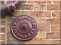
Wall tie, T & W BRADLEY NEWARK
Thomas Bradley took over the established Wellington Foundry of J & W Midworth, located in Northgate, in 1867. This wall tie is prominently lettered.
Image: © Alan Murray-Rust
Taken: 31 Aug 2012
0.02 miles
8
Otter Park
Sculpture by Judith Bluck in Otter Park by The River Trent
Image: © Richard Croft
Taken: 5 Nov 2012
0.02 miles
9
![Newark historic riverside trail [7]](https://s3.geograph.org.uk/geophotos/03/81/92/3819239_5a15554d_120x120.jpg)
Newark historic riverside trail [7]
The [very small] Otter Park with a wharfside haulage path in the foreground. Trail leaflet available from Newark TIC.
Image: © Christine Johnstone
Taken: 18 Jan 2014
0.02 miles
10
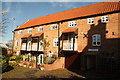
Huddlestones Wharf
Attractive houses in former wharf buildings behind Millgate
Image: © Richard Croft
Taken: 5 Nov 2012
0.02 miles