IMAGES TAKEN NEAR TO
Sleaford Road, NEWARK, NG24 1NL
Introduction
This page details the photographs taken nearby to Sleaford Road, NG24 1NL by members of the Geograph project.
The Geograph project started in 2005 with the aim of publishing, organising and preserving representative images for every square kilometre of Great Britain, Ireland and the Isle of Man.

There are currently over 7.5m images from over14,400 individuals and you can help contribute to the project by visiting https://www.geograph.org.uk
Image Map
Images are licensed for reuse under creativecommons.org/licenses/by-sa/2.0
Notes
- Clicking on the map will re-center to the selected point.
- The higher the marker number, the further away the image location is from the centre of the postcode.
Image Listing (222 Images Found)
Images are licensed for reuse under creativecommons.org/licenses/by-sa/2.0
Image
Details
Distance
1
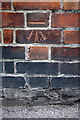
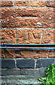
Benchmark on wall at side of #42 Wellington Road
Ordnance Survey cut mark benchmark described on the Bench Mark Database at http://www.bench-marks.org.uk/bm24255
Image: © Roger Templeman
Taken: 1 May 2016
0.04 miles
2
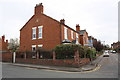
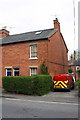
Houses of Wellington Road at Sleaford Road junction
There is an OS benchmark Image on the brick wall near the gate which gives access to the rear of #42 Wellington Road
Image: © Roger Templeman
Taken: 1 May 2016
0.05 miles
3
Bench mark, 5 Friary Road
A rather worn cut mark. Not easy to spot, it's directly below the 'C' of Beacon, just above the telephone cables. See http://www.geograph.org.uk/photo/3116553 for location.
Image: © Alan Murray-Rust
Taken: 31 Aug 2012
0.06 miles
4
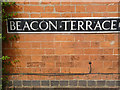
Beacon Terrace
The alley leads to the terrace of houses with this name, set back behind Friary Road without any other road access. The bench mark illustrated here http://www.geograph.org.uk/photo/3116551 is on the gable wall on the left, hidden by the hedge.
Image: © Alan Murray-Rust
Taken: 31 Aug 2012
0.06 miles
5
Benchmark on #5 Friary Road
Ordnance Survey cut mark benchmark described on the Bench Mark Database at http://www.bench-marks.org.uk/bm24253
Image: © Roger Templeman
Taken: 1 May 2016
0.06 miles
6
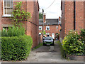
#5 Friary Road at Beacon Terrace junction
There is an OS benchmark Image on the right hand side of the house near its front corner
Image: © Roger Templeman
Taken: 1 May 2016
0.06 miles
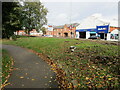
7
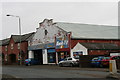
Kwik Fit in Sleaford Road, Newark-on-Trent
The building was originally a bus garage.
Image: © Chris
Taken: 2 Mar 2014
0.06 miles
9
Line of Civil War defences, Friary Gardens, Newark
The defences were constructed between 1642 and 1646 and overlay the precinct wall of the Newark Friary https://historicengland.org.uk/listing/the-list/list-entry/1016020
Image: © Jonathan Thacker
Taken: 26 Oct 2021
0.07 miles
10
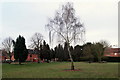
Friary Park, Sleaford Road, Newark, Notts.
Friary Park seen from the Queen's Street/Appleton Gate junction. On the right-hand side of the house on the right-hand margin of this picture, and behind it, are a couple of grey-stone built residential properties in a grey-stone wall-surrounded plot of land known as The Friary. In 1507 a group of Grey Friars, or "Observant Friars" of the Franciscan Order, began to serve the community from their base here that include "gardens and/or an orchard". Although there is little trace of the friary it seems possible that these gardens were part of the original C16th religious house site.
Image: © David Hallam-Jones
Taken: 1 Feb 2015
0.08 miles