IMAGES TAKEN NEAR TO
North Church Walk, NEWARK, NG24 1GX
Introduction
This page details the photographs taken nearby to North Church Walk, NG24 1GX by members of the Geograph project.
The Geograph project started in 2005 with the aim of publishing, organising and preserving representative images for every square kilometre of Great Britain, Ireland and the Isle of Man.

There are currently over 7.5m images from over14,400 individuals and you can help contribute to the project by visiting https://www.geograph.org.uk
Image Map
Images are licensed for reuse under creativecommons.org/licenses/by-sa/2.0
Notes
- Clicking on the map will re-center to the selected point.
- The higher the marker number, the further away the image location is from the centre of the postcode.
Image Listing (1128 Images Found)
Images are licensed for reuse under creativecommons.org/licenses/by-sa/2.0
Image
Details
Distance
1
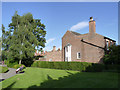
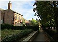
Kirkwood House, Appletongate
Early Victorian (c1840) house, adjoining the churchyard. Listed Grade II.
Image: © Alan Murray-Rust
Taken: 4 Sep 2012
0.00 miles
2

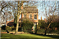
Side view of Kirkwood House
The main part of the house dates from about 1840 but has later additions seen here https://historicengland.org.uk/listing/the-list/list-entry/1196285
Image: © Jonathan Thacker
Taken: 24 Jul 2020
0.01 miles
3
Kirkwood
View across St.Mary's churchyard to the handsome 19th century house, Kirkwood, 4 Kirkgate http://www.geograph.org.uk/photo/360404
Image: © Richard Croft
Taken: 2 Feb 2013
0.01 miles
4
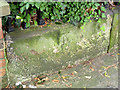
Bench mark, St Mary's churchyard
Cut mark in the stone base of the railings on the north side of the path through the churchyard.
Image: © Alan Murray-Rust
Taken: 31 Aug 2012
0.01 miles
5
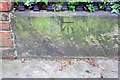
Benchmark on wall of path through St Mary's Church churchyard
Ordnance Survey cut mark benchmark described on the Bench Mark Database at http://www.bench-marks.org.uk/bm45344
Image: © Roger Templeman
Taken: 1 May 2016
0.01 miles
6
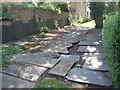
Footpath through St Mary's Church churchyard
There is an OS benchmark Image on the concrete wall on the left hand side of the path at the junction with the hedge
Image: © Roger Templeman
Taken: 1 May 2016
0.01 miles
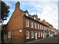
7
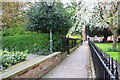
North Church Walk, Newark on Trent
Image: © Jonathan Thacker
Taken: 16 Oct 2022
0.02 miles
8
Graveyard for gravestones
Headstones taken from the churchyard of St. Mary Magdalene's church and laid to rest.
Image: © Jonathan Thacker
Taken: 5 Aug 2011
0.02 miles
9
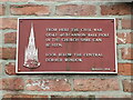
Civil War Plaque in Mount Lane
Helps pick out where a cannon=ball crashed into the church spire of St Mary Magdalene visible above to the right.
Image: © El Loco
Taken: 23 May 2021
0.02 miles
10
Appletongate, Newark
The first two buildings are 11 and 13 Appletongate http://www.britishlistedbuildings.co.uk/en-384863-11-and-13-appleton-gate-newark-nottingha
Image: © Jonathan Thacker
Taken: 26 Oct 2012
0.02 miles