IMAGES TAKEN NEAR TO
St. Saviours Gardens, NOTTINGHAM, NG2 3LH
Introduction
This page details the photographs taken nearby to St. Saviours Gardens, NG2 3LH by members of the Geograph project.
The Geograph project started in 2005 with the aim of publishing, organising and preserving representative images for every square kilometre of Great Britain, Ireland and the Isle of Man.

There are currently over 7.5m images from over14,400 individuals and you can help contribute to the project by visiting https://www.geograph.org.uk
Image Map
Images are licensed for reuse under creativecommons.org/licenses/by-sa/2.0
Notes
- Clicking on the map will re-center to the selected point.
- The higher the marker number, the further away the image location is from the centre of the postcode.
Image Listing (275 Images Found)
Images are licensed for reuse under creativecommons.org/licenses/by-sa/2.0
Image
Details
Distance
1
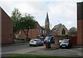
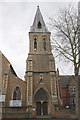
The Meadows: St Saviour's Church and St Saviour's Gardens
These houses and a new road layout replaced straight streets of Victorian terraced houses in the 1970s.
Image: © John Sutton
Taken: 29 Apr 2013
0.03 miles
2
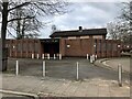
The Riverway
There appears to be no pictures of this pub when it was open.
Image: © David Lally
Taken: 3 Mar 2023
0.05 miles
3
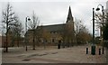
St. Saviour's in the Meadows
Built in 1863 and standing on the former Arkwright Street.
Image: © Mick Garratt
Taken: 7 Nov 2007
0.05 miles
4
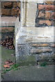
Benchmark on St Saviour's Church
Ordnance Survey cut mark benchmark described on the Bench Mark Database at http://www.bench-marks.org.uk/bm47832
Image: © Roger Templeman
Taken: 1 Apr 2013
0.06 miles
5
St Saviour's Church, Arkwright Walk
There is an OS benchmark Image on the front of the buttress on the left hand side of the tower
Image: © Roger Templeman
Taken: 1 Apr 2013
0.06 miles
6
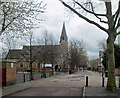
Arkwright Walk
Until the 1970s, Arkwright Street was one of the two main routes to Trent Bridge, Bridgford, Loughborough and Melton (the other was London Road). It was lined with shops and crowded with buses and trolleybuses. St Saviour's Church is all that remains of the street I remember from my schooldays.
Image: © John Sutton
Taken: 7 Apr 2014
0.06 miles
7
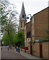
Arkwright Walk and St Saviour's Church
The Victorian houses and shops of The Meadows district were replaced by the houses shown here. The rectilinear Victorian street plan has gone almost completely. This pedestrian street was Arkwright Street, once lined with shops and the main bus and trolleybus route from the city centre to Trent Bridge. St Saviour's dates from 1863. My grandparents were married there in 1905.
Image: © John Sutton
Taken: 16 Apr 2011
0.07 miles
8
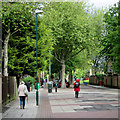
Up Arkwright Walk
Pedestrianised since the Meadows was rebuilt in the 1970s, this was once Arkwright Street, the main route from the city centre to Trent Bridge and a busy bus and trolleybus route.
Image: © John Sutton
Taken: 19 May 2015
0.07 miles
9
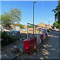
Building site on Arkwright Walk
Building new houses on Arkwright Walk (once Arkwright Street, the main bus route into the city from the south). Many of the Victorian residential and shopping streets in The Meadows were demolished in the 1970s. Now the replacement council houses are being replaced.
Image] gives an idea of the south end of Arkwright Walk in 2013.
Image: © John Sutton
Taken: 26 Jun 2018
0.07 miles
10
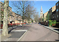
A May morning in Arkwright Walk
Until the 1970s, when much of the Victorian Meadows district was bulldozed, this was Arkwright Street, one of the main roads into the city from the south. St Saviour's Church is on the right of this view towards the city centre.
Image: © John Sutton
Taken: 2 May 2013
0.07 miles