IMAGES TAKEN NEAR TO
Crocus Street, NOTTINGHAM, NG2 3EB
Introduction
This page details the photographs taken nearby to Crocus Street, NG2 3EB by members of the Geograph project.
The Geograph project started in 2005 with the aim of publishing, organising and preserving representative images for every square kilometre of Great Britain, Ireland and the Isle of Man.

There are currently over 7.5m images from over14,400 individuals and you can help contribute to the project by visiting https://www.geograph.org.uk
Image Map
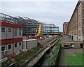
Images are licensed for reuse under creativecommons.org/licenses/by-sa/2.0
Notes
- Clicking on the map will re-center to the selected point.
- The higher the marker number, the further away the image location is from the centre of the postcode.
Image Listing (822 Images Found)
Images are licensed for reuse under creativecommons.org/licenses/by-sa/2.0
Image
Details
Distance
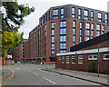
1
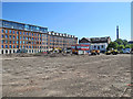
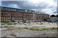
Crocus Street: site for new flats
Work has begun to build 350 flats for rent on a former industrial site on the north side of Crocus Street. The large building to the left is the former Hicking Pentecost textile warehouse, now flats.
Image: © John Sutton
Taken: 26 May 2017
0.02 miles
2
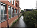
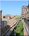
Tinker's Leen
This is a flood-relief channel. The Hicking Pentecost factory, now 275 flats, is on the left and London Road in the distance.
Image: © John Sutton
Taken: 24 Aug 2010
0.02 miles
3
Building site by Tinker's Leen
Flats for rent are being built on a large brownfield site on Crocus Street. Image] gives a better idea of them and links to other pictures.
Image: © John Sutton
Taken: 1 Jul 2019
0.02 miles
4
The Meadows: new housing on Crocus Street
A big block of flats for rent is being built on a brownfield site. This September-morning view is towards London Road.
Image: © John Sutton
Taken: 25 Sep 2018
0.02 miles
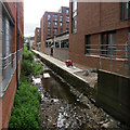
5
Along Tinker's Leen
The former Hicking Pentecost textile works, now flats, is on the right. Flats for rent are to be built on the cleared industrial site to the left, fronting Crocus Street.
Image: © John Sutton
Taken: 26 May 2017
0.03 miles
6
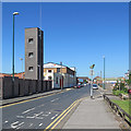
Along Crocus Street
The tower of the new Fire Station is on the left, on the corner of Wallet Street.
Image: © John Sutton
Taken: 26 May 2017
0.03 miles
7
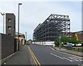
Changing Crocus Street
Steelwork for new flats has gone up on a site which has been vacant for a number of years. For comparison, see Image] (June 2015), Image] and Image] (both May 2017). The tower of the new Fire Station is on the left and a glimpse of the former Hicking Pentecost works (in Image) on the extreme right.
Image: © John Sutton
Taken: 13 May 2018
0.03 miles
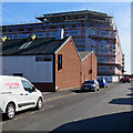
8
The rear of the Hicking Pentecost building
Now flats, this was originally a lace factory. This is the view across cleared land from Crocus Street. Stephen Richards photographed the Queen's Road side from London Road in 2012: Image
Image: © John Sutton
Taken: 1 Jun 2015
0.03 miles
9
Steelwork by Tinker's Leen
Flats for rent are being built on a brownfield site between Crocus Street and Tinker's Leen. For comparison, see Image] (May 2017).
Image: © John Sutton
Taken: 13 May 2018
0.03 miles
10
New flats on Crocus Street
Flats for rent are nearing completion on a large brownfield site between Crocus Street and Tinker's Leen. Image] shows an earlier stage of the project and Image] the land before building began.
Image: © John Sutton
Taken: 1 Jul 2019
0.03 miles