IMAGES TAKEN NEAR TO
Great North Road, NEWARK, NG23 6ED
Introduction
This page details the photographs taken nearby to Great North Road, NG23 6ED by members of the Geograph project.
The Geograph project started in 2005 with the aim of publishing, organising and preserving representative images for every square kilometre of Great Britain, Ireland and the Isle of Man.

There are currently over 7.5m images from over14,400 individuals and you can help contribute to the project by visiting https://www.geograph.org.uk
Image Map
Images are licensed for reuse under creativecommons.org/licenses/by-sa/2.0
Notes
- Clicking on the map will re-center to the selected point.
- The higher the marker number, the further away the image location is from the centre of the postcode.
Image Listing (25 Images Found)
Images are licensed for reuse under creativecommons.org/licenses/by-sa/2.0
Image
Details
Distance
1
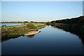
River Trent
View east from Muskham Bridge on a calm summer evening
Image: © Richard Croft
Taken: 19 Aug 2009
0.03 miles
2
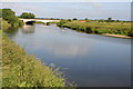
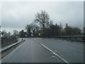
Muskham Bridge
Muskham Bridge carrying the A616 over the River Trent.
Image: © Philip Halling
Taken: 1 Jul 2013
0.04 miles
3
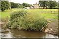
Fishing pegs
Steps to fishing pegs on the Trent by Muskham Bridge, submerged by high water after recent heavy rain
Image: © Richard Croft
Taken: 17 Jul 2012
0.05 miles
5
Viaduct approaching Muskham Bridge
Viaduct carrying the A616 as it approaches Muskham Bridge.
Image: © Philip Halling
Taken: 1 Jul 2013
0.06 miles
6
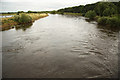
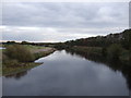
River Trent
The River Trent from Muskham Bridge, swollen after recent heavy rain http://www.geograph.org.uk/photo/1451694
Image: © Richard Croft
Taken: 17 Jul 2012
0.07 miles
7
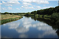
River Trent
View east from Muskham Bridge on the old Great North Road
Image: © Richard Croft
Taken: 26 Jun 2011
0.07 miles
9
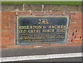
Smeaton's Arches, commemorative plaque
This records the various stages of rebuild and refurbishment. It gives the date of the later widening as 1929, but the English Heritage listings give the date as 1922, and certainly this was the date of Muskham Bridge.
Image: © Alan Murray-Rust
Taken: 14 Sep 2012
0.07 miles
10
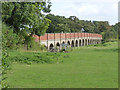
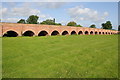
Smeaton's arches, near Muskham Bridge
This is the most northerly, and longest, set of flood relief arches created by John Smeaton for his 1770 improvement of the Great North Road. This view show how each set of arches rises slightly in the middle; this applies equally to the shorter groups. This side shows the concrete widening carried out by Nottinghamshire County Council and completed in 1929. Listed Grade II. (Each group of arches has a separate listing - there are 74 arches in sets of between 1 and 18 arches).
Image: © Alan Murray-Rust
Taken: 14 Sep 2012
0.07 miles