IMAGES TAKEN NEAR TO
Mill Lane, NEWARK, NG23 6AJ
Introduction
This page details the photographs taken nearby to Mill Lane, NG23 6AJ by members of the Geograph project.
The Geograph project started in 2005 with the aim of publishing, organising and preserving representative images for every square kilometre of Great Britain, Ireland and the Isle of Man.

There are currently over 7.5m images from over14,400 individuals and you can help contribute to the project by visiting https://www.geograph.org.uk
Image Map
Images are licensed for reuse under creativecommons.org/licenses/by-sa/2.0
Notes
- Clicking on the map will re-center to the selected point.
- The higher the marker number, the further away the image location is from the centre of the postcode.
Image Listing (86 Images Found)
Images are licensed for reuse under creativecommons.org/licenses/by-sa/2.0
Image
Details
Distance
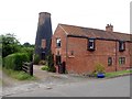
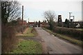
1
Mill Lane, Caunton
View towards the edge of the village. The former mill is further along in this direction.
Image: © Andrew Hill
Taken: 8 Sep 2012
0.03 miles
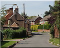
3
Mill Lane, Caunton
A variety of attractive houses and cottages can be found in this characterful village. There are lots of corners along every lane, so that is impossible to go straight through the village in a rush.
Image: © Andrew Hill
Taken: 8 Sep 2012
0.06 miles
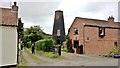
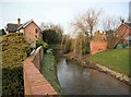
5
Caunton Mill
Also known as Sharp's Mill, this grade II listed building was built in the early 1800s but was out of use by the 1930s.
Image: © Graham Hogg
Taken: 2 Aug 2016
0.10 miles
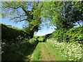
6
Field by the old mill, Caunton
View from the footpath to the former mill and some houses at the western edge of the village.
Image: © Andrew Hill
Taken: 8 Sep 2012
0.10 miles
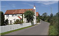
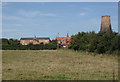
9
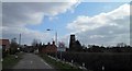
Caunton Village ahead
On the approach to Caunton can be seen the windmill now converted into a private dwelling. Caunton Mill, also known as Sharp's Mill, was a brick tower windmill with an ogee cap, built before 1825. It was out of use in the 1930s. The height of the tower is 43 feet. Bet you have a nice view from this dwelling.
Image: © roger geach
Taken: 1 Feb 2010
0.15 miles