IMAGES TAKEN NEAR TO
Church Mews, NOTTINGHAM, NG2 2GH
Introduction
This page details the photographs taken nearby to Church Mews, NG2 2GH by members of the Geograph project.
The Geograph project started in 2005 with the aim of publishing, organising and preserving representative images for every square kilometre of Great Britain, Ireland and the Isle of Man.

There are currently over 7.5m images from over14,400 individuals and you can help contribute to the project by visiting https://www.geograph.org.uk
Image Map
Images are licensed for reuse under creativecommons.org/licenses/by-sa/2.0
Notes
- Clicking on the map will re-center to the selected point.
- The higher the marker number, the further away the image location is from the centre of the postcode.
Image Listing (113 Images Found)
Images are licensed for reuse under creativecommons.org/licenses/by-sa/2.0
Image
Details
Distance
1
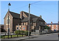
The Kings School
This is how it appears on some OS maps, which no longer mark it as a place of worship. Its condition suggests that it is no longer in use by the school, which has its main centre a few streets away.
Image: © Alan Murray-Rust
Taken: 20 Mar 2009
0.02 miles
2
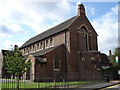
St Gabriel Church, Bathley Street
Built about 1900, I think this may no longer be an active place of worship.
Image: © Oxymoron
Taken: 3 Sep 2008
0.02 miles
3
The Full Gospel Revival Centre on Bathley Street
Image: © Ian S
Taken: 29 Aug 2020
0.03 miles
4
Meadows Muslim Centre, Collgate Road
It looks as though these buildings were once a local school, probably attached to the church next door on Bathley Street [http://www.geograph.org.uk/photo/948761].
Image: © Oxymoron
Taken: 3 Sep 2008
0.03 miles
5
South end of Mundella Road, the Meadows
Seen from Bathley Street.
Image: © Richard Vince
Taken: 10 Jun 2013
0.03 miles
6
The Meadows: St Faith's Church
St Faith's is a full gospel revival centre at the corner of Collygate Road and Bathley Street.
Image: © John Sutton
Taken: 5 Jul 2021
0.03 miles
7

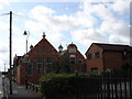
Former school buildings
Now the Meadows Muslim Centre, these buildings were once the local infants and junior school for the area before being absorbed into the former Mundella Grammar School, once the main grammar school for the south side of Nottingham. They were then used as Library and sixth form facilities. The initials NSB show that this was a foundation of the Nottingham Schools Board.
Image: © Alan Murray-Rust
Taken: 20 Mar 2009
0.03 miles
8
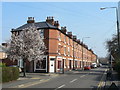
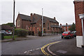
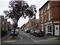
Bathley Street
Looking east from Wilford Grove. Three storey terraced housing.
Image: © Alan Murray-Rust
Taken: 20 Mar 2009
0.03 miles
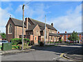
9
Housing style mix
On the corner of the Victoria Emabnkment recreation ground. 2- and 3-storey Victorian terraces with late 20th century equivalent.
Image: © Alan Murray-Rust
Taken: 20 Mar 2009
0.04 miles
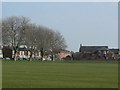
10
Wilford Grove
The area of grass shows where the road has been cut to prevent its use as a rat run, although still available to cyclists.
Image: © Alan Murray-Rust
Taken: 20 Mar 2009
0.04 miles