IMAGES TAKEN NEAR TO
Holgate Road, NOTTINGHAM, NG2 2EB
Introduction
This page details the photographs taken nearby to Holgate Road, NG2 2EB by members of the Geograph project.
The Geograph project started in 2005 with the aim of publishing, organising and preserving representative images for every square kilometre of Great Britain, Ireland and the Isle of Man.

There are currently over 7.5m images from over14,400 individuals and you can help contribute to the project by visiting https://www.geograph.org.uk
Image Map
Images are licensed for reuse under creativecommons.org/licenses/by-sa/2.0
Notes
- Clicking on the map will re-center to the selected point.
- The higher the marker number, the further away the image location is from the centre of the postcode.
Image Listing (136 Images Found)
Images are licensed for reuse under creativecommons.org/licenses/by-sa/2.0
Image
Details
Distance
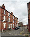
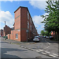
2
Along Wilford Crescent East
Three-storey terraces of a type built all over Nottingham in the late 19th century, photographed on a bright September morning.
Image: © John Sutton
Taken: 13 Sep 2019
0.03 miles
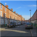
3
Wilford Crescent South
Part of the central part of the Meadows not affected by the 1970s redevelopment.
Image: © Alan Murray-Rust
Taken: 20 Mar 2009
0.03 miles
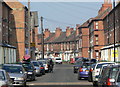
4
On Wilford Crescent East
The corners of Holgate Road and Muskham Street on a bright September morning. The white cranes on the skyline are on the Unity Square site near Nottingham railway station which is shown in Image] and Image
Image: © John Sutton
Taken: 13 Sep 2019
0.03 miles
5

Mundella Road, looking north
The houses between Mundella Road ands Wilford Grove are much newer than the rest of the area, but still too old to be bomb-damage replacements.
Image: © Alan Murray-Rust
Taken: 20 Mar 2009
0.04 miles
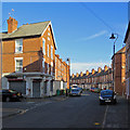
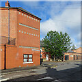
6
The Meadows: at the corner of Mundella Road
Three-storey red-brick terraces like this are common in all of Nottingham's Victorian suburbs - but not many terraces end in a sharp wedge like this one. Wilford Crescent East is to the left, Mundella Road straight ahead.
Image: © John Sutton
Taken: 5 Jul 2021
0.05 miles
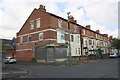
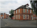
7
The Meadows: terra cotta on the corner
The junction of Wilford Crescent East and Mundella Road on a July morning. The copper cupola on the right is on the public library on the corner of Wilford Grove. Image] is another view of the house on the left.
Image: © John Sutton
Taken: 5 Jul 2021
0.06 miles
8
#138 Wilford Grove at Holgate Road junction
Ordnance Survey records show that in 1962 a benchmark levelled at 25.524m above Newlyn Datum was present at the centre of the left hand face of the building, possibly now hidden behind the green cabinet
Image: © Luke Shaw
Taken: 11 May 2019
0.07 miles
9
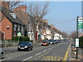
Wilford Grove
One of the main streets through the Meadows. This part was not affected by the major redevelopment of the 1970s and retains its Victorian buildings
Image: © Alan Murray-Rust
Taken: 20 Mar 2009
0.07 miles
10
The Meadows: the former Plumptre Arms
The building on the corner of Muskham Street and Bunbury Street was originally one of many pubs in The Meadows.
Image: © John Sutton
Taken: 1 Jul 2019
0.07 miles