IMAGES TAKEN NEAR TO
Wilford Grove, NOTTINGHAM, NG2 2DX
Introduction
This page details the photographs taken nearby to Wilford Grove, NG2 2DX by members of the Geograph project.
The Geograph project started in 2005 with the aim of publishing, organising and preserving representative images for every square kilometre of Great Britain, Ireland and the Isle of Man.

There are currently over 7.5m images from over14,400 individuals and you can help contribute to the project by visiting https://www.geograph.org.uk
Image Map
Images are licensed for reuse under creativecommons.org/licenses/by-sa/2.0
Notes
- Clicking on the map will re-center to the selected point.
- The higher the marker number, the further away the image location is from the centre of the postcode.
Image Listing (108 Images Found)
Images are licensed for reuse under creativecommons.org/licenses/by-sa/2.0
Image
Details
Distance
1
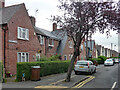
Mundella Road, Nottingham
Council housing of 1920-22 by the city's Housing Architect, T. Cecil Howitt. Each semi has a catslide roof.
Image: © Stephen Richards
Taken: 19 Jun 2015
0.03 miles
2
Wilford Grove, the Meadows
Looking north from Bathley Street.
Image: © Richard Vince
Taken: 10 Jun 2013
0.03 miles
3
South end of Mundella Road, the Meadows
Seen from Bathley Street.
Image: © Richard Vince
Taken: 10 Jun 2013
0.04 miles
4
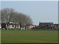
Housing style mix
On the corner of the Victoria Emabnkment recreation ground. 2- and 3-storey Victorian terraces with late 20th century equivalent.
Image: © Alan Murray-Rust
Taken: 20 Mar 2009
0.05 miles
5
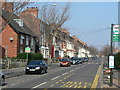
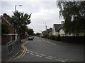
Wilford Grove
One of the main streets through the Meadows. This part was not affected by the major redevelopment of the 1970s and retains its Victorian buildings
Image: © Alan Murray-Rust
Taken: 20 Mar 2009
0.05 miles
6
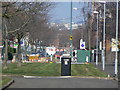
Wilford Grove
The area of grass shows where the road has been cut to prevent its use as a rat run, although still available to cyclists.
Image: © Alan Murray-Rust
Taken: 20 Mar 2009
0.05 miles
7
#138 Wilford Grove at Holgate Road junction
Ordnance Survey records show that in 1962 a benchmark levelled at 25.524m above Newlyn Datum was present at the centre of the left hand face of the building, possibly now hidden behind the green cabinet
Image: © Luke Shaw
Taken: 11 May 2019
0.06 miles
8
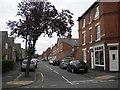
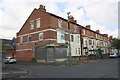
Bathley Street
Looking east from Wilford Grove. Three storey terraced housing.
Image: © Alan Murray-Rust
Taken: 20 Mar 2009
0.06 miles
9

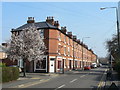
Mundella Road, looking north
The houses between Mundella Road ands Wilford Grove are much newer than the rest of the area, but still too old to be bomb-damage replacements.
Image: © Alan Murray-Rust
Taken: 20 Mar 2009
0.07 miles
10
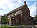
St Gabriel Church, Bathley Street
Built about 1900, I think this may no longer be an active place of worship.
Image: © Oxymoron
Taken: 3 Sep 2008
0.07 miles