IMAGES TAKEN NEAR TO
Market Place, NEWARK, NG22 9BL
Introduction
This page details the photographs taken nearby to Market Place, NG22 9BL by members of the Geograph project.
The Geograph project started in 2005 with the aim of publishing, organising and preserving representative images for every square kilometre of Great Britain, Ireland and the Isle of Man.

There are currently over 7.5m images from over14,400 individuals and you can help contribute to the project by visiting https://www.geograph.org.uk
Image Map
Images are licensed for reuse under creativecommons.org/licenses/by-sa/2.0
Notes
- Clicking on the map will re-center to the selected point.
- The higher the marker number, the further away the image location is from the centre of the postcode.
Image Listing (137 Images Found)
Images are licensed for reuse under creativecommons.org/licenses/by-sa/2.0
Image
Details
Distance
1
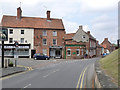
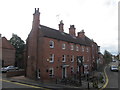
Ollerton Village centre
The junction of Wellow Road, Station Road and the Market Place.
Image: © Alan Murray-Rust
Taken: 8 Aug 2014
0.01 miles
2
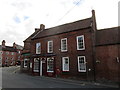
The Old Post Office, Ollerton
Dates from the early eighteenth century https://historicengland.org.uk/listing/the-list/list-entry/1302573
Image: © Jonathan Thacker
Taken: 20 Oct 2018
0.01 miles
3
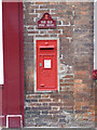
Ollerton Post Office postbox ref NG22 131
Standard GR wall box in what used to be the local Post Office. The house name plate incorporates a miniature version.
Image: © Alan Murray-Rust
Taken: 8 Aug 2014
0.01 miles
4
Ollerton Village, Notts
A "T" junction formed by the B6461, a.k.a. Station Road (ahead) and the A616 (a road between Sheffield-Newark) seen from near the main door into St Giles' Church. The White House Hotel on the left faces several local businesses.
Image: © David Hallam-Jones
Taken: 22 Feb 2015
0.01 miles
5
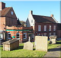
Ollerton Village, Notts.
A partial view of a couple of local businesses and a house from the graveyard of St Giles' Church.The florist's shop, "Forget Me Notts", looks as though it may have previously been a bank?
Image: © David Hallam-Jones
Taken: 22 Feb 2015
0.01 miles
6
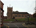
St Giles Church, Ollerton, Notts
This Grade II-listed church, dating from c.1790, is seen here from Station Road. The outside tables in the picture belong to The White Hart pub, a former meeting place for forestry officials from the Dukeries and supervisory staff from the hop fields. The latter were once to be found at the side of the River Maun (1790-1892). Previously Ollerton was at the crossroads of some well established routes between Newark-Worksop and Mansfield-Lincoln and it is said that this public house became a rendezvous venue for such male supervisors. Wellow Road is seen ahead.
Image: © David Hallam-Jones
Taken: 29 Oct 2014
0.01 miles
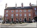
7
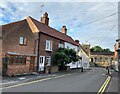
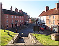
Old Ollerton Village Centre
Historical dwellings and the Church of St. Giles can be seen here along with a few evening drinkers outside the White Hart pub.
Image: © Jonathan Clitheroe
Taken: 2 Aug 2022
0.01 miles
9
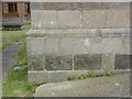
Bench mark, St Giles' Church, Ollerton
See http://www.geograph.org.uk/photo/4113782 for location.
Image: © Alan Murray-Rust
Taken: 8 Aug 2014
0.01 miles
10
The White Hart public house
One of two Sam Smith's public houses in Ollerton
Image: © Ian S
Taken: 18 Mar 2012
0.01 miles