1
Bungalow ruin in Halam
Image: © Neil Theasby
Taken: 31 May 2019
0.01 miles
2
New housing development, Radley Road, Halam
On land formerly forming part of the farmyard of Halam House Farm.
Image: © Alan Murray-Rust
Taken: 6 Sep 2020
0.02 miles
3
St Michael's Close, Halam
A very short cul de sac off
Image, apparently named after the saint to whom the church down the road is dedicated.
Image: © Richard Vince
Taken: 7 May 2016
0.04 miles
4
Radley Road or Church Lane, Halam
The maps seem unable to make up their mind as to the identity of this thoroughfare, and show it as "Radley Road or Church Lane". It certainly enters the village from the west as Radley Road, and the church is at its east end, so either would make sense. Perhaps the good denizens of Halam cannot decide either.
Image: © Richard Vince
Taken: 7 May 2016
0.04 miles
5
Barn in Halam
A good example of its type, almost certainly destined to be converted into a house.
Image: © Jonathan Thacker
Taken: 5 Nov 2010
0.06 miles
6
Gray Lane, Halam
Off
Image The dead end sign is unexpected, as it is marked on both the Landranger and Explorer maps as continuing as a through byway. Perhaps it is unsuitable for motor vehicles beyond a certain point.
Image: © Richard Vince
Taken: 7 May 2016
0.06 miles
7
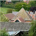
Roofscape at Halam
Showing a wide variety of roofing material, including traditional pantiles, Victorian slate, 20th century concrete tiles, asbestos cement sheeting and corrugated metal sheeting. The Pyramidal roof belongs to an 18th century dovecote, latterly a store but now converted to residential use, Listed Grade II.
Image: © Alan Murray-Rust
Taken: 6 Sep 2020
0.07 miles
8
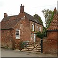
Ashdene, Radley Road, Halam
Mid 18th century farmhouse, Listed Grade II.
Image: © Alan Murray-Rust
Taken: 6 Sep 2020
0.07 miles
9
Ashdene, Radley Road, Halam
Mid 18th century farmhouse, Listed Grade II.
Image: © Alan Murray-Rust
Taken: 6 Sep 2020
0.08 miles
10
View over Halam
From the footpath above the churchyard.
Image: © Alan Murray-Rust
Taken: 6 Sep 2020
0.08 miles


