IMAGES TAKEN NEAR TO
Irving Close, NEWARK, NG22 8FB
Introduction
This page details the photographs taken nearby to Irving Close, NG22 8FB by members of the Geograph project.
The Geograph project started in 2005 with the aim of publishing, organising and preserving representative images for every square kilometre of Great Britain, Ireland and the Isle of Man.

There are currently over 7.5m images from over14,400 individuals and you can help contribute to the project by visiting https://www.geograph.org.uk
Image Map
Images are licensed for reuse under creativecommons.org/licenses/by-sa/2.0
Notes
- Clicking on the map will re-center to the selected point.
- The higher the marker number, the further away the image location is from the centre of the postcode.
Image Listing (69 Images Found)
Images are licensed for reuse under creativecommons.org/licenses/by-sa/2.0
Image
Details
Distance
1
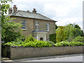
The Grange, Main Street
Early 19th century farmhouse in ashlar, suggesting that this was one of the more prosperous local farms. The porch is later. Listed Grade II.
Image: © Alan Murray-Rust
Taken: 1 Jun 2014
0.06 miles
2
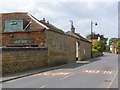
Grange Farm Main Street
Barn walls and gateway in coursed rubble stonework. There is a bench mark http://www.geograph.org.uk/photo/4015800 on the near corner of the barn.
Image: © Alan Murray-Rust
Taken: 1 Jun 2014
0.06 miles
3
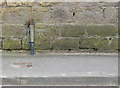
Bench mark, Grange Farm
See http://www.geograph.org.uk/photo/4015795 for location.
Image: © Alan Murray-Rust
Taken: 1 Jun 2014
0.06 miles
5
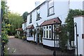
Main Street, Farnsfield, Notts.
Public footpath access point with a link to Irving Close is seen here at the side of the Grange Cottage Guest House, a 300 year old Georgian property. The photograph was taken from near the junction with The Ridgeway, obliquely opposite.
Image: © David Hallam-Jones
Taken: 20 Dec 2014
0.08 miles
6
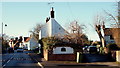
Island Cottage, Farnsfield, Notts.
The Ridgeway (< a road name) can be reached via Southwell Road on the left or via the passageway on the right. This is a view looking towards Main Street that commences near The Plough public house ahead.
Image: © David Hallam-Jones
Taken: 30 Jan 2015
0.08 miles
7
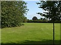
Parfitt Drive Field, Farnsfield
A well maintained public area.
Image: © Alan Murray-Rust
Taken: 20 Sep 2020
0.08 miles
8
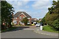
Parfitt Close, Farnsfield
Late 20th century infill housing.
Image: © Alan Murray-Rust
Taken: 20 Sep 2020
0.08 miles
9
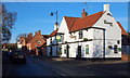
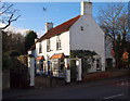
Main Street, Farnsfield, Notts.
The Plough Inn looking towards the centre of the village. The Plough dates from the C17th although it was rebuilt later c.1740s.
Image: © David Hallam-Jones
Taken: 6 Dec 2014
0.09 miles
10
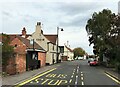
Bus Stop and Public House in Farnsfield
These amenities are located at the eastern end of Main Street. I called in to the Plough Inn (pictured here) which was notable for its friendly barman and charming old inglenook fireplace in the front room.
Image: © Jonathan Clitheroe
Taken: 9 Oct 2020
0.09 miles