IMAGES TAKEN NEAR TO
Plantation Road, NEWARK, NG22 0RD
Introduction
This page details the photographs taken nearby to Plantation Road, NG22 0RD by members of the Geograph project.
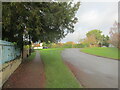
The Geograph project started in 2005 with the aim of publishing, organising and preserving representative images for every square kilometre of Great Britain, Ireland and the Isle of Man.

There are currently over 7.5m images from over14,400 individuals and you can help contribute to the project by visiting https://www.geograph.org.uk
Image Map
Images are licensed for reuse under creativecommons.org/licenses/by-sa/2.0
Notes
- Clicking on the map will re-center to the selected point.
- The higher the marker number, the further away the image location is from the centre of the postcode.
Image Listing (54 Images Found)
Images are licensed for reuse under creativecommons.org/licenses/by-sa/2.0
Image
Details
Distance
1
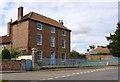
Cush Pool House
Dating back to the early 18th century, although the main front seen here is late 18th century. Listed Grade II. The railings in front of the house are late 19th century and are also Listed Grade II for group value.
Image: © Alan Murray-Rust
Taken: 22 Aug 2014
0.00 miles
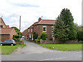
2
Cushpool House, East Markham
Substantial eighteenth century house http://www.britishlistedbuildings.co.uk/en-419462-cush-pool-house-east-markham-nottinghams The railings in front are also listed http://www.britishlistedbuildings.co.uk/en-419464-wall-railings-and-gate-extending-in-fron
Image: © Jonathan Thacker
Taken: 4 Jan 2013
0.01 miles
3
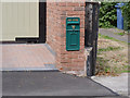
A long way from home
This former postbox has made its way across the Irish Sea to find a home as a private mailbox.
Image: © Alan Murray-Rust
Taken: 22 Aug 2014
0.02 miles
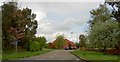
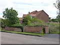
4
Plantation Road
A street in East Markham.
Image: © steven ruffles
Taken: 12 Dec 2021
0.03 miles
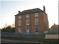
5
Pond Farmhouse
An early 18th century house with a main front from the end of the same century. Listed Grade II.
Image: © Alan Murray-Rust
Taken: 22 Aug 2014
0.03 miles
6
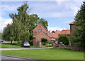
Farm buildings at Pond Farm
The range of buildings dates from between the late 18th century and the 20th century, and have relatively recently been converted to residential use. LG II for group value.
Image: © Alan Murray-Rust
Taken: 22 Aug 2014
0.04 miles
7
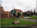
Best kept village sign
There is no indication as to when the award was made
Image: © Graham Hogg
Taken: 27 Jan 2020
0.04 miles
8
The site of Pond House
There is a bench mark http://www.geograph.org.uk/photo/4139682 just to the left of the lighter central section of the brick wall.
Image: © Alan Murray-Rust
Taken: 22 Aug 2014
0.06 miles
9
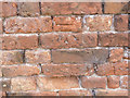
Bench mark, Lincoln Road, East Markham
See http://www.geograph.org.uk/photo/4139693 for location.
Image: © Alan Murray-Rust
Taken: 22 Aug 2014
0.06 miles