IMAGES TAKEN NEAR TO
Ossington Road, NEWARK, NG22 0AB
Introduction
This page details the photographs taken nearby to Ossington Road, NG22 0AB by members of the Geograph project.
The Geograph project started in 2005 with the aim of publishing, organising and preserving representative images for every square kilometre of Great Britain, Ireland and the Isle of Man.

There are currently over 7.5m images from over14,400 individuals and you can help contribute to the project by visiting https://www.geograph.org.uk
Image Map
Images are licensed for reuse under creativecommons.org/licenses/by-sa/2.0
Notes
- Clicking on the map will re-center to the selected point.
- The higher the marker number, the further away the image location is from the centre of the postcode.
Image Listing (27 Images Found)
Images are licensed for reuse under creativecommons.org/licenses/by-sa/2.0
Image
Details
Distance
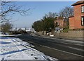
1
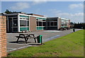
Kneesall Primary School
A path goes through the edge of the pleasant school grounds.
Image: © Andrew Hill
Taken: 8 Sep 2012
0.06 miles
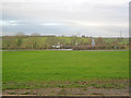
2
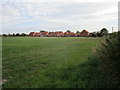
Kneesall: Elm Tree Close and fields
Elm Tree Close is a relatively recent addition to the village.
Image: © Jonathan Thacker
Taken: 4 Oct 2018
0.06 miles
4
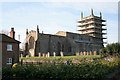
Under repair
Church of St. Bartholomew, Kneesall under repair as seen in the morning sun.
Image: © roger geach
Taken: 31 Jan 2009
0.11 miles
6
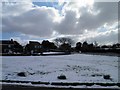
Village green at Kneesall
Looking west across a simple triangle of grass to the A616 heading towards Ollerton.
Image: © Trevor Rickard
Taken: 24 Dec 2011
0.12 miles
7
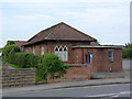
Kneesall Village Hall
Now slowly decaying following the conversion of part of the parish church into a new Community Centre http://www.geograph.org.uk/photo/4024703
Image: © Alan Murray-Rust
Taken: 1 Jun 2014
0.13 miles
9
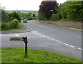
Fingerpost, Ollerton Road/Eakring Road, Kneesall
An unusually short version of the traditional Nottinghamshire C C cast iron post.
It is also an unusual survivor along an A road, where modern Worboys style signs are the norm.
Image: © Alan Murray-Rust
Taken: 1 Jun 2014
0.13 miles
10
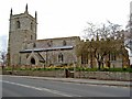
Church of St. Bartholomew, Kneesall
This 13th century church stands in the centre of Kneesall on the A616 as it passes through the village on a sharp bend. It has recently undergone extensive re-roofing work.
Image: © Christine Hasman
Taken: 28 Mar 2004
0.13 miles