IMAGES TAKEN NEAR TO
Beardsley Gardens, NOTTINGHAM, NG2 1QD
Introduction
This page details the photographs taken nearby to Beardsley Gardens, NG2 1QD by members of the Geograph project.
The Geograph project started in 2005 with the aim of publishing, organising and preserving representative images for every square kilometre of Great Britain, Ireland and the Isle of Man.

There are currently over 7.5m images from over14,400 individuals and you can help contribute to the project by visiting https://www.geograph.org.uk
Image Map
Images are licensed for reuse under creativecommons.org/licenses/by-sa/2.0
Notes
- Clicking on the map will re-center to the selected point.
- The higher the marker number, the further away the image location is from the centre of the postcode.
Image Listing (254 Images Found)
Images are licensed for reuse under creativecommons.org/licenses/by-sa/2.0
Image
Details
Distance
1
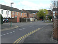
Beardsley Gardens
Typical cul-de-sac in the Meadows. This provides rear access for motor traffic, with main frontages facing onto a series of pedestrian ways linking to the main local facilities. Main distributor roads run round the periphery of the housing. This is generally known as Radburn layout, based on the original development in this style in Radburn, New Jersey (USA). See Wikipedia http://en.wikipedia.org/wiki/Radburn,_New_Jersey .
Image: © Alan Murray-Rust
Taken: 7 Apr 2009
0.02 miles
2
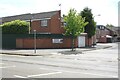
Junction of Meadows Way and Beardsley Gardens
There is an Ordnance Survey benchmark Image on the brick wall near the left hand edge of the image, just left of the wall angle
Image: © Luke Shaw
Taken: 11 May 2019
0.03 miles
3
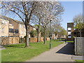
Kirkwhite Walk
One of the main pedestrian routes through the Meadows area, named after local poet Henry Kirke White.
Image: © Alan Murray-Rust
Taken: 1 Apr 2012
0.04 miles
4

Benchmark on wall on south side of Meadows Way
Ordnance Survey cut mark benchmark described on the Bench Mark Database at www.bench-mark.org.uk/bm70816
Image: © Luke Shaw
Taken: 11 May 2019
0.04 miles
5
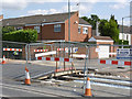
Impending track laying at Bardsley Gardens
The ramp fill in the excavation for the track in the far carriageway will provide access for lorry loads o concrete to feed the track laying machine http://www.geograph.org.uk/photo/3984032.
Image: © Alan Murray-Rust
Taken: 14 May 2014
0.04 miles
6
Gap in the tracks
The temporary bridge will be moved when an alternative access into Beardsley Gardens has been constructed.
Image: © Alan Murray-Rust
Taken: 21 Jul 2014
0.04 miles
7
Meadows Way at Beardsley Gardens
The footway on the northern side of the road is now in use again.
Image: © Alan Murray-Rust
Taken: 7 Mar 2014
0.04 miles
8
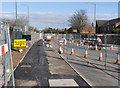
Service relaying on Meadows Way West (4)
This is the main site for the works in the immediate locality, with major excavations in and alongside the carriageway.
Image: © Alan Murray-Rust
Taken: 21 Jun 2012
0.04 miles
9
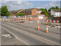
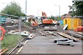
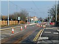
Meadows Way, looking west
Construction of the outbound track is well under way. This is the location of Meadows North tram stop.
Image: © Alan Murray-Rust
Taken: 4 Apr 2014
0.04 miles
10
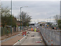
Meadows Way West
The one way flow along the road switches sides here. Such changes have changed side and location at frequent intervals during tramway construction, but will soon be a thing of the past.
Image: © Alan Murray-Rust
Taken: 20 Mar 2015
0.04 miles