IMAGES TAKEN NEAR TO
St. Georges Drive, NOTTINGHAM, NG2 1NX
Introduction
This page details the photographs taken nearby to St. Georges Drive, NG2 1NX by members of the Geograph project.
The Geograph project started in 2005 with the aim of publishing, organising and preserving representative images for every square kilometre of Great Britain, Ireland and the Isle of Man.

There are currently over 7.5m images from over14,400 individuals and you can help contribute to the project by visiting https://www.geograph.org.uk
Image Map
Images are licensed for reuse under creativecommons.org/licenses/by-sa/2.0
Notes
- Clicking on the map will re-center to the selected point.
- The higher the marker number, the further away the image location is from the centre of the postcode.
Image Listing (371 Images Found)
Images are licensed for reuse under creativecommons.org/licenses/by-sa/2.0
Image
Details
Distance
1
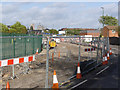
Track bed preparation on Meadows Way
Following completion of services renewals and diversions, work has started on forming the track bed.
Image: © Alan Murray-Rust
Taken: 27 Oct 2013
0.02 miles
2
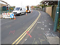
Official graffiti
The marks on the road and footway surfaces indicate the extent of services affected by tramway construction.
Image: © Alan Murray-Rust
Taken: 23 Apr 2012
0.03 miles
3
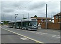
On Meadows Way West
The tram has dropped its passengers at Nottingham Station, as shown by the temporary board in the windscreen, and is running light to Enterprise Way to reverse direction.
Image: © Alan Murray-Rust
Taken: 27 Jul 2015
0.03 miles
4
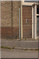
Cut Bench Mark, Meadows Way
There is a cut bench mark to the right of the weed. Bench Mark Database: http://www.bench-marks.org.uk/bm42480
Image: © Mark Anderson
Taken: 9 Aug 2012
0.03 miles
5
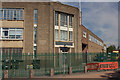
Thomas & Betts Ltd
This industrial building also carries the brand name Furse which is a range of lightning protection and earthing systems. There is a cut bench mark on the wall to the left of the doorway and a closer view can be seen here: Image
Image: © Mark Anderson
Taken: 9 Aug 2012
0.03 miles
6
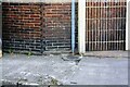
Benchmark on building on north side of Wilford Road
The ordnance Survey cut mark benchmark is on bricks to the left of the cable guide and described on the Bench Mark Database at www.bench-marks.org.uk/bm42480
Image: © Luke Shaw
Taken: 11 May 2019
0.03 miles
7
Building on NW side of Wilford Road
There is an Ordnance Survey benchmark Image in bricks on the left hand side of the doorway
Image: © Luke Shaw
Taken: 11 May 2019
0.03 miles
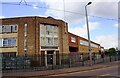
8
More track on Meadows Way
This is now in place right past the Furze factory.
Image: © Alan Murray-Rust
Taken: 1 Dec 2013
0.03 miles
9
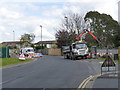
Sewer relocation
Meadows Way West at Gritley Mews. The temporary lights will become a full road closure for 6 weeks from April 30 2012.
Image: © Alan Murray-Rust
Taken: 23 Apr 2012
0.04 miles
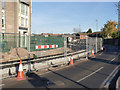
10
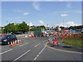
Meadows Way West at Wilford Road
Work on services is still in progress at this location although there is track laid just a few 10s of metres away.
Image: © Alan Murray-Rust
Taken: 26 Jul 2013
0.04 miles