IMAGES TAKEN NEAR TO
Castle Park, NOTTINGHAM, NG2 1AH
Introduction
This page details the photographs taken nearby to Castle Park, NG2 1AH by members of the Geograph project.
The Geograph project started in 2005 with the aim of publishing, organising and preserving representative images for every square kilometre of Great Britain, Ireland and the Isle of Man.

There are currently over 7.5m images from over14,400 individuals and you can help contribute to the project by visiting https://www.geograph.org.uk
Image Map
Images are licensed for reuse under creativecommons.org/licenses/by-sa/2.0
Notes
- Clicking on the map will re-center to the selected point.
- The higher the marker number, the further away the image location is from the centre of the postcode.
Image Listing (260 Images Found)
Images are licensed for reuse under creativecommons.org/licenses/by-sa/2.0
Image
Details
Distance
1
A B C D
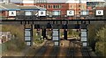
Signal gantry on the approach to Nottingham Station.
Image: © Alan Murray-Rust
Taken: 24 Mar 2019
0.04 miles
2

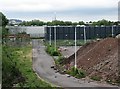
Castle Park industrial units
An industrial development with more awareness of design than most.
Image: © Alan Murray-Rust
Taken: 24 Mar 2019
0.04 miles
3
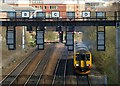
Pulling away from Nottingham Station
East Midlands trains class 156 coupled to a class 158. Not showing a destination, and although it is the right formation for a train to Liverpool, the time was wrong and it didn't turn up the Leen Valley line.
Image: © Alan Murray-Rust
Taken: 24 Mar 2019
0.04 miles
4
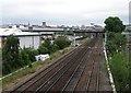
The western approach to Nottingham Station
In the days of steam, there were extensive goods yards to the left of the four-track main line occupying all of the land now given over to retail warehouses and the Inland Revenue buildings. The large Nottingham Midland engine shed (code 16A) was to the right - its site is now a retail park, Castle Park. For the view to the west from here, see Image
Image: © John Sutton
Taken: 20 Jul 2012
0.05 miles
6
Castle Park: the site of Nottingham Midland engine shed
In the days of steam this was the site of the three large roundhouses (actually square) and extensive sidings of Nottingham Midland Motive Power Depot (coded 16A), which stretched to Wilford Road in the east and Middle Furlong Road (long since cleared) at the northern edge of The Meadows. Image] shows the railway lines to the north of the trees on the extreme left. The chimney of Eastcroft Incinerator is on the skyline in the centre of the picture.
Image: © John Sutton
Taken: 20 Jul 2012
0.07 miles
8

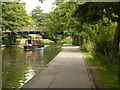
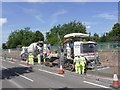
Track laying on Meadows Way West
The full train, consisting of concrete supply lorry, concrete laying unit and at the back the pad laying unit.
Image: © Alan Murray-Rust
Taken: 26 Jul 2013
0.09 miles
9
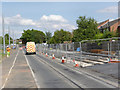
Track laying on Meadows Way West
The slipform concrete-laying unit.
Image: © Alan Murray-Rust
Taken: 26 Jul 2013
0.09 miles
10
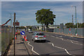
Meadows Way West
The outbound track is now under construction; some overhead poles are also in place.
Image: © Alan Murray-Rust
Taken: 21 Jul 2014
0.10 miles