IMAGES TAKEN NEAR TO
Warsop Vale, MANSFIELD, NG20 8XR
Introduction
This page details the photographs taken nearby to NG20 8XR by members of the Geograph project.
The Geograph project started in 2005 with the aim of publishing, organising and preserving representative images for every square kilometre of Great Britain, Ireland and the Isle of Man.

There are currently over 7.5m images from over14,400 individuals and you can help contribute to the project by visiting https://www.geograph.org.uk
Image Map
Images are licensed for reuse under creativecommons.org/licenses/by-sa/2.0
Notes
- Clicking on the map will re-center to the selected point.
- The higher the marker number, the further away the image location is from the centre of the postcode.
Image Listing (16 Images Found)
Images are licensed for reuse under creativecommons.org/licenses/by-sa/2.0
Image
Details
Distance
1
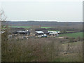
William Wood Farm
Seen from the former colliery spoil tip.
Image: © Alan Murray-Rust
Taken: 27 Mar 2011
0.01 miles

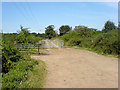
3
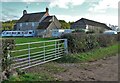
William Wood Farm on William Wood Lane
Clearly accommodating caravans is a worthwhile sideline on this farm.
Image: © Neil Theasby
Taken: 4 Nov 2021
0.04 miles
4
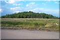
Warsop Main Colliery pit tip
Warsop Main Colliery was on this site until its closure in 1989.
Image: © Ann B
Taken: 31 May 2005
0.06 miles
5
Old colliery site, Warsop
The site of Warsop Main Colliery which closed in 1989 showing what once was the stock yard.
Image: © Ann B
Taken: 31 May 2005
0.06 miles
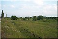
7
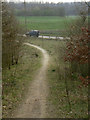
Path off the tip
The area of the former Warsop Main colliery and its spoil heap have been landscaped and opened up as a recreational area with footpaths.
Image: © Alan Murray-Rust
Taken: 27 Mar 2011
0.14 miles
8
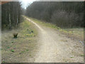
Path on the tip
The area of the former Warsop Main colliery and its spoil heap have been landscaped and opened up as a recreational area with footpaths.
Image: © Alan Murray-Rust
Taken: 27 Mar 2011
0.15 miles
9

Rails in the road
The remains of the mineral railway which served Warsop Main Colliery.
Image: © Jonathan Thacker
Taken: 14 Aug 2021
0.17 miles
10
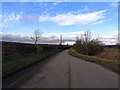
William Wood Lane
Looking north-northwest up William Wood Lane bridleway. To the left is a footpath heading towards Lord Stubbin's Wood.
Image: © James Hill
Taken: 23 Aug 2007
0.18 miles