IMAGES TAKEN NEAR TO
Church Road, MANSFIELD, NG20 0SF
Introduction
This page details the photographs taken nearby to Church Road, NG20 0SF by members of the Geograph project.
The Geograph project started in 2005 with the aim of publishing, organising and preserving representative images for every square kilometre of Great Britain, Ireland and the Isle of Man.

There are currently over 7.5m images from over14,400 individuals and you can help contribute to the project by visiting https://www.geograph.org.uk
Image Map
Images are licensed for reuse under creativecommons.org/licenses/by-sa/2.0
Notes
- Clicking on the map will re-center to the selected point.
- The higher the marker number, the further away the image location is from the centre of the postcode.
Image Listing (85 Images Found)
Images are licensed for reuse under creativecommons.org/licenses/by-sa/2.0
Image
Details
Distance
1
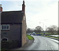
Warsop Mill Vicinity, Church Warsop, Notts.
Beyond this "Old Mill House", a Grade II-listed early C18th property, a slight traffic hold-up ahead - on the A60 (Church Road) - marks the exit from the public car park serving visitors to The Carrs Nature Reserve (a local nature reserve). The centre of Market Warsop lies 10-15 minutes ahead on foot.
Image: © David Hallam-Jones
Taken: 23 Jan 2016
0.01 miles
2
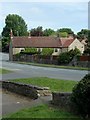
Village scene, Church Warsop
Looking across the A60 Church Road from by the entrance to the car park for The Carrs.
Image: © Andrew Hill
Taken: 15 May 2014
0.01 miles
3

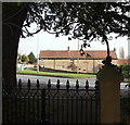
Picnic site at the Carrs
No takers today! The Carrs car park, church of St Peter and Paul and the War Memorial in the background.
Image: © Andy Stephenson
Taken: 27 Dec 2014
0.02 miles
4
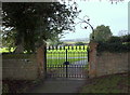
Parish Church Vicinity, Church Warsop, Notts.
On the south side of the church, and at a lower level, a path exits onto the pavement at the side of Church Road (the A60). Users are obliged to pass through this Grade II-listed gateway with panelled ashlar piers with hipped ashlar caps. The iron spearhead gates are seen here, as is the scrolled foliate wrought-iron arch (a.k.a. overthrow). A red car can be seen on Eastlands Lane passing the side of some cottages.
Image: © David Hallam-Jones
Taken: 23 Jan 2016
0.02 miles
5
Parish Church, Church Warsop, Notts.
Entrance to the southwest side of the graveyard from Church Street, i.e. the A60. Users are obliged to pass through this Grade II-listed gateway with panelled ashlar piers and hipped ashlar caps. The iron spearhead gates can be seen here, as can the scrolled foliate wrought-iron arch (a.k.a. overthrow).
Image: © David Hallam-Jones
Taken: 23 Jan 2016
0.02 miles
6
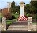
Warsop Mill Vicinity, Church Warsop, Notts.
The Grade II-listed, limestone ashlar and granite war memorial, c.1920, and the tower of the parish church are seen here from The Carrs Nature Reserve car park, off the A60.
Image: © David Hallam-Jones
Taken: 23 Jan 2016
0.02 miles
7

Warsop Mill Vicinity, Church Warsop, Notts.
The Grade II-listed, limestone ashlar and granite war memorial, c.1920, is seen from the side of Church Street, i.e. the A60. It sits in the corner of a car park set aside for visitors to The Carrs Nature Reserve. Warsop Mill is situated behind the photographer, on the opposite side of the A60.
Image: © David Hallam-Jones
Taken: 23 Jan 2016
0.02 miles
8
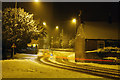
Church Road - Eastlands Lane junction
A night time snow scene, with snow still falling. The long exposure means that the only sign of a passing car is a red light trail.
Image: © Andy Stephenson
Taken: 18 Jan 2013
0.02 miles
9
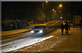
A winter scene on Church Road
Close to The Carrs car park, Warsop.
Image: © Andy Stephenson
Taken: 18 Jan 2013
0.02 miles
10
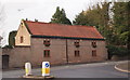
Eastlands Lane, Church Warsop, Notts.
Western end of Eastlands Lane at its junction with Church Road.
Image: © David Hallam-Jones
Taken: 23 Jan 2016
0.03 miles