IMAGES TAKEN NEAR TO
George Shooter Court, MANSFIELD, NG20 0QJ
Introduction
This page details the photographs taken nearby to George Shooter Court, NG20 0QJ by members of the Geograph project.
The Geograph project started in 2005 with the aim of publishing, organising and preserving representative images for every square kilometre of Great Britain, Ireland and the Isle of Man.

There are currently over 7.5m images from over14,400 individuals and you can help contribute to the project by visiting https://www.geograph.org.uk
Image Map
Images are licensed for reuse under creativecommons.org/licenses/by-sa/2.0
Notes
- Clicking on the map will re-center to the selected point.
- The higher the marker number, the further away the image location is from the centre of the postcode.
Image Listing (17 Images Found)
Images are licensed for reuse under creativecommons.org/licenses/by-sa/2.0
Image
Details
Distance
1
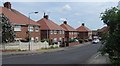
Houses on Birkland Avenue, Warsop
A residential street.
Image: © Andrew Hill
Taken: 15 May 2014
0.14 miles
2
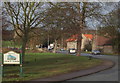
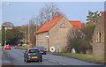
Church Road, Church Warsop, Notts.
The boundary with Market Warsop is two minutes walk away behind the photographer and traffic on the A60 is seen here entering and leaving Church Warsop. The parish church is visible behind the trees, with the C18th Grade II-listed water mill, Warsop Mill, on the right topped with bright orange tiles. The River Meden and the mill pond, plus a public car park serving The Carrs nature reserve, are situated on the left.
Image: © David Hallam-Jones
Taken: 23 Jan 2016
0.20 miles
3
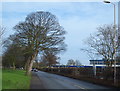
Church Street, Market Warsop, Notts.
At the midpoint along this road (the A60), Market Warsop's Church Street becomes Church Road, Church Warsop. On the right are buildings on the Meden School and Technology College site and opposite these, The Carrs, a local park and local nature reserve. The River Meden meanders through The Carrs. Church Warsop is a 3-4 minute walk ahead, with Market Warsop 4-5 minutes behind the photographer.
Image: © David Hallam-Jones
Taken: 23 Jan 2016
0.21 miles
4
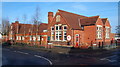
Hetts Lane, Market Warsop, Notts.
Hetts Lane Nursery and infants School - dated to 1905 - is seen here between Hetts Lane as it approaches Church Street on the left and Burns Lane on the right.
Image: © David Hallam-Jones
Taken: 23 Jan 2016
0.22 miles
5
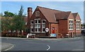
School, Warsop
Primary school buildings at the corner of Hetts Lane and Burns Lane.
Image: © Andrew Hill
Taken: 15 May 2014
0.22 miles
6
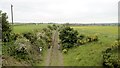
Welbeck Colliery branch line
The colliery closed in 2010 and nature is already reclaiming the trackbed.
Image: © Chris Morgan
Taken: 31 May 2016
0.22 miles
7
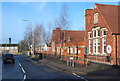
Hetts Lane, Market Warsop, Notts.
The T junction with the A60, i.e. Church Street, is seen here with Hetts Lane Nursery and infants School on the right. The school was founded in 1905.
Image: © David Hallam-Jones
Taken: 23 Jan 2016
0.22 miles
8
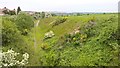
Disused railway line to Welbeck Colliery
Closed as recently as 2010 but nature is already well in control! Compare this with view in 2009; http://www.geograph.org.uk/photo/2221012
The colliery is now gone, but energy is still being drawn from this area - see the massive solar farm on the horizon.
Image: © Chris Morgan
Taken: 31 May 2016
0.22 miles
9
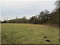
Grassland and woodland by the River Meden
Image: © Jonathan Thacker
Taken: 28 Jan 2022
0.23 miles
10
Church Road, Church Warsop, Notts.
The converted C18th Grade II-listed water mill, Warsop Mill, plus a glimpse of the parish church through the trees on the right.
Image: © David Hallam-Jones
Taken: 23 Jan 2016
0.23 miles