IMAGES TAKEN NEAR TO
Clumber Street, MANSFIELD, NG20 0LS
Introduction
This page details the photographs taken nearby to Clumber Street, NG20 0LS by members of the Geograph project.
The Geograph project started in 2005 with the aim of publishing, organising and preserving representative images for every square kilometre of Great Britain, Ireland and the Isle of Man.

There are currently over 7.5m images from over14,400 individuals and you can help contribute to the project by visiting https://www.geograph.org.uk
Image Map
Images are licensed for reuse under creativecommons.org/licenses/by-sa/2.0
Notes
- Clicking on the map will re-center to the selected point.
- The higher the marker number, the further away the image location is from the centre of the postcode.
Image Listing (50 Images Found)
Images are licensed for reuse under creativecommons.org/licenses/by-sa/2.0
Image
Details
Distance
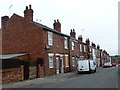
1
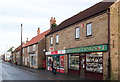
High Street, Market Warsop, Notts.
A view from the cul-de-sac end of High Street. The site occupied by Grandma's Bakery, parallel with the second parked car on the right, is a 200 square metre plot identified by the local Council in January 2016 the site for a new housing development.
Image: © David Hallam-Jones
Taken: 23 Jan 2016
0.07 miles
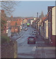
2
High Street, Market Warsop, Notts.
The greater part of High Street lies behind the photographer. Here High Street peters out to become a short pedestrian link with the A60, approximately 15-20 paces ahead.
Image: © David Hallam-Jones
Taken: 23 Jan 2016
0.07 miles
3
High Street, Market Warsop, Notts.
In January 2016 the local Council identified a piece of land of 200 square metres on the right hand side of The Crate and Grape pub (behind Grandma's Bakery) as a potential housing development site.
Image: © David Hallam-Jones
Taken: 23 Jan 2016
0.07 miles
4
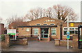
High Street, Market Warsop, Notts.
The library.
Image: © David Hallam-Jones
Taken: 23 Jan 2016
0.08 miles
6
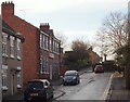
High Street, Market Warsop, Notts.
The cul-de-sac end of High Street peters out ahead and all that remains of it is a short path - behind the photographer - that provides pedestrians with a link to those houses on the edge of the town, i.e. on either side of the A60 that leads to Mansfield.
Image: © David Hallam-Jones
Taken: 23 Jan 2016
0.08 miles
7
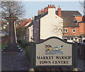
Market Warsop, Notts.
This name-sign marks the entrance to Market Warsop for those coming from the Mansfield and Mansfield Woodhouse directions. The A60 curves to the left here (not visible here but to the left of this marble memorial). Pedestrians however, can follow a footpath to the right of this sign and join the closed end of the High Street where the latter has become a cul-de-sac twenty or so paces ahead.
Image: © David Hallam-Jones
Taken: 23 Jan 2016
0.08 miles
8
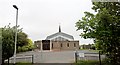
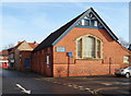
St Teresa?s Catholic Church, Market Warsop
Built in 1974. Read more at; http://www.saint-joseph.org.uk/st-teresas/
Image: © Chris Morgan
Taken: 31 May 2016
0.08 miles
9
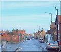
High Street, Market Warsop, Notts.
A view along High Street towards the town centre's main crossroads dominated by the distant white painted Talbot public house.
Image: © David Hallam-Jones
Taken: 23 Jan 2016
0.09 miles
10
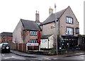
Clumber Street, Market Warsop, Notts.
The town's Methodist Church occupies a corner site formed by Portland Street (where the car is parked) and Portland Street that can be seen linking up with Sherwood Street (the B6035) ahead. Clumber Street was formerly known as Back Street.
Image: © David Hallam-Jones
Taken: 23 Jan 2016
0.09 miles