IMAGES TAKEN NEAR TO
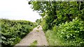
Blackberry Way, MANSFIELD, NG20 0BU
Introduction
This page details the photographs taken nearby to Blackberry Way, NG20 0BU by members of the Geograph project.
The Geograph project started in 2005 with the aim of publishing, organising and preserving representative images for every square kilometre of Great Britain, Ireland and the Isle of Man.

There are currently over 7.5m images from over14,400 individuals and you can help contribute to the project by visiting https://www.geograph.org.uk
Image Map
Images are licensed for reuse under creativecommons.org/licenses/by-sa/2.0
Notes
- Clicking on the map will re-center to the selected point.
- The higher the marker number, the further away the image location is from the centre of the postcode.
Image Listing (14 Images Found)
Images are licensed for reuse under creativecommons.org/licenses/by-sa/2.0
Image
Details
Distance
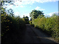
1
Sookholme Lane, Market Warsop
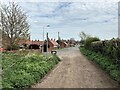
The western edge of the town pictured from the western edge of the grid square. At the point where the byway becomes a metalled road.
Image: © Jonathan Clitheroe
Taken: 19 Apr 2022
0.12 miles
2
Sookholme Lane, Market Warsop, Notts.
The eastern end of Sookholme Lane. This is the point at which the lane changes from being a rural lane passing through agricultural land to a residential road. The hamlet of Sookholme lies 2-2.5 miles behind the photographer and the A60 (the main Market Warsop - Mansfield road) 1/2 mile ahead.
Image: © David Hallam-Jones
Taken: 28 Jan 2016
0.12 miles
3
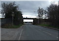
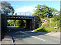
Railway bridge over Mansfield Road (A60)
Heading south west.
Image: © JThomas
Taken: 16 Mar 2014
0.12 miles
4
Sookholme Lane, Market Warsop, Notts.
This is the front (boundary) wall belonging to the final (or first) house on the residentially-developed section of Sookholme Lane. The remainder of it, approximately two miles in length, is a track passing through agricultural land. A third of the way along its length from this end, a stone bridge carries users across the River Meden
Image: © David Hallam-Jones
Taken: 28 Jan 2016
0.12 miles
5
Railway Bridge over A60
Railway bridge over the A60 entry to Warsop.
Image: © James Hill
Taken: 29 Jun 2007
0.14 miles
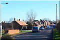
6
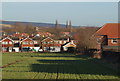
Stonebridge Lane, Market Warsop, Notts.
Houses on Stonebridge Lane seen from Sookholme Lane.
Image: © David Hallam-Jones
Taken: 28 Jan 2016
0.15 miles
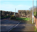
7
Askew Lane
Askew Lane, facing away from the entrance to the allotments.
Image: © James Hill
Taken: 29 Jun 2007
0.22 miles
8
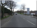
Mansfield Road (A60), Warsop
Heading south west.
Image: © JThomas
Taken: 16 Mar 2014
0.22 miles
10
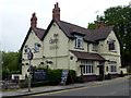
The Gate
A public house and restaurant. The menu offers a 72oz steak though the barman said he had never known anyone order one.
Image: © Graham Hogg
Taken: 31 May 2016
0.23 miles