IMAGES TAKEN NEAR TO
Pleasley Vale, MANSFIELD, NG19 8RP
Introduction
This page details the photographs taken nearby to NG19 8RP by members of the Geograph project.
The Geograph project started in 2005 with the aim of publishing, organising and preserving representative images for every square kilometre of Great Britain, Ireland and the Isle of Man.

There are currently over 7.5m images from over14,400 individuals and you can help contribute to the project by visiting https://www.geograph.org.uk
Image Map
Images are licensed for reuse under creativecommons.org/licenses/by-sa/2.0
Notes
- Clicking on the map will re-center to the selected point.
- The higher the marker number, the further away the image location is from the centre of the postcode.
Image Listing (58 Images Found)
Images are licensed for reuse under creativecommons.org/licenses/by-sa/2.0
Image
Details
Distance
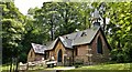
2
St Chad's Church at Pleasley Vale
Built in 1876 by Joseph Paget, a wealthy local businessman, for the residents and workers of Pleasley Vale.
Image: © Graham Hogg
Taken: 2 Jun 2014
0.00 miles
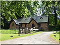
3
St Chad's church, Pleasley Vale
The church is tucked away among trees. The notice board had fallen down, but contained up to date information about regular Sunday services.
Image: © Andrew Hill
Taken: 1 Oct 2011
0.00 miles
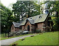
4
St Chad's Church in Pleasley Vale
Attractive church rebuilt here on the Nottinghamshire side of the county boundary in 1880 by local estate-owner Joseph Paget. This strategic relocation took the church out of the jurisdiction of the diocese of Lichfield following a family marriage dispute. The interior of the structure features unusual polished pitchpine and mahogany panelling.
Image: © Jonathan Clitheroe
Taken: 26 Jul 2014
0.01 miles
5
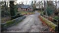
Bridge over the River Meden and St. Chad's Church, Pleasley Vale
The original church was built on the Derbyshire side of the River Meden but following unfavourable comments by the vicar about the marriage of the landowner’s daughter to an older man the building was dismantled and re-erected on the Nottinghamshire side of the river. This act caused the church to be moved from one diocese to another thus removing the errant vicar. References https://en.wikipedia.org/wiki/Church_of_St_Chad%2C_Pleasley_Vale and http://www.stuffynwood.com/st_chads.html
The River Meden forms the boundary between Derbyshire (behind the viewpoint) and Nottinghamshire (ahead).
The church is a Grade II Listed Building.
Image: © Alan Walker
Taken: 4 Dec 2017
0.01 miles
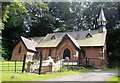
6
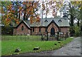
St Chad's Church in Pleasley Vale
This brick church was rebuilt here on the Nottinghamshire side of the county boundary in 1880 by local estate-owner Joseph Paget. This strategic relocation took the church out of the jurisdiction of the diocese of Lichfield following a family marriage dispute.
Image: © Neil Theasby
Taken: 4 Nov 2020
0.01 miles
7

St. Chad's church, Pleasley Vale
A church with an interesting history http://stuffynwood.com/st_chads.html
Image: © Jonathan Thacker
Taken: 28 Nov 2017
0.01 miles
8
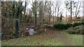
The River Meden
The photograph shows a public footpath running by the side of the River Meden. Behind the viewpoint the footpath leads into an area known as Little Matlock.
Ahead the footpath crosses a road leading, to the right, St Chads Church and Pleasley Vale. To the left, the road becomes a private track leading to Image
Crossing the road the footpath passes through some scrubland before reaching a meadow beyond which it joins the road through Pleasley Vale.
In the meadow there is a junction with a Image
***
To see a photograph taken from the point where the public footpath crosses the road ahead, click here:- Image
Image: © Alan Walker
Taken: 4 Dec 2017
0.05 miles
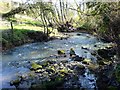
9
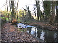
The River Meden
In that part of Pleasley Vale known as Little Matlock, no doubt a reference to that part of the Derwent Valley around Matlock Bath.
Image: © Jonathan Thacker
Taken: 28 Nov 2017
0.06 miles
10
River Meden
The River Meden as it winds through Pleasley Vale.
Image: © James Hill
Taken: 6 Apr 2008
0.06 miles