IMAGES TAKEN NEAR TO
Booth Avenue, MANSFIELD, NG19 7TE
Introduction
This page details the photographs taken nearby to Booth Avenue, NG19 7TE by members of the Geograph project.
The Geograph project started in 2005 with the aim of publishing, organising and preserving representative images for every square kilometre of Great Britain, Ireland and the Isle of Man.

There are currently over 7.5m images from over14,400 individuals and you can help contribute to the project by visiting https://www.geograph.org.uk
Image Map
Images are licensed for reuse under creativecommons.org/licenses/by-sa/2.0
Notes
- Clicking on the map will re-center to the selected point.
- The higher the marker number, the further away the image location is from the centre of the postcode.
Image Listing (101 Images Found)
Images are licensed for reuse under creativecommons.org/licenses/by-sa/2.0
Image
Details
Distance
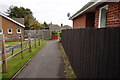
3
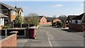
Booth Avenue
The photograph shows the lower end of Booth Avenue, Pleasley and is looking toward its junction with Church Lane.
Turning left at the junction, Church Lane leads to a Image
***
See also these photographs by Ian S:-
Image,
Image and
Image
Image: © Alan Walker
Taken: 28 Mar 2019
0.06 miles
4
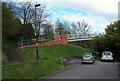
Pleasley NG19, Near Mansfield, Notts.
Church Lane became divided into two (two cul-de-sacs) when the A617 dual carriageway (Chesterfield Road North) was built - date unknown - and as a result pedestrians wishing to access Common Lane, Outgang Lane or St Michael's Church on the other side of the A617, tend to use the footbridge ahead to save themselves a detour of a mile or so.
Image: © David Hallam-Jones
Taken: 28 Apr 2013
0.06 miles
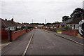
5
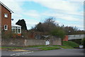
Pleasley NG19, Near Mansfield, Notts.
Booth Avenue - on the left - branches off the southern-most section of Church Lane. Church Lane was divided into two two cul-de-sacs when the A617 dual carriageway (Chesterfield Road North)) was built - construction date unknown - and as a result, pedestrians wishing to access either Common Lane, Outgang Lane or St Michael's Church on the other side of the A617, now tend to use the footbridge ahead to save themselves a detour of a mile or so.
Image: © David Hallam-Jones
Taken: 28 Apr 2013
0.06 miles
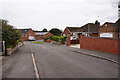
6
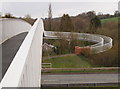
Pleasley NG19, Near Mansfield, Notts.
Church Lane was divided into two by the construction of Chesterfield Road North (the A617 dual-carriageway) - date unknown - and as a result pedestrians wishing to access either Common Lane, Outgang Lane or St Michael's Church on the other side of the A617, tend to use this footbridge to save themselves a detour of a mile or so. It is wheelchair-friendly but is said to be "unsuitable for horses".
Image: © David Hallam-Jones
Taken: 28 Apr 2013
0.06 miles
7
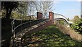
Footbridge over the A617
The photograph shows the southerly access ramp onto the bridge over the A617 from Church Lane.
Until the dual carriageway was constructed the A617 ran through Pleasley Village on what is still called Chesterfield Road. The construction of this new road separated the village from its Parish Church, hence the need for the bridge.
An OS map dated 1937-61 from the National Library of Scotland https://maps.nls.uk/geo/explore/side-by-side/#zoom=16&lat=53.1746&lon=-1.2471&layers=10&right=osm shows the earlier route of the A617 and the position of the footbridge over the dual carriageway.
***
See also these photographs by,
David Dixon:- Image,
Ian S:- Image,
Ian S:- Image and
Jonathan Thacker:- Image
Image: © Alan Walker
Taken: 28 Mar 2019
0.06 miles
8
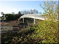
Footbridge over Chesterfield Road
Connects the two parts of Church Lane divided by the A617.
Image: © Jonathan Thacker
Taken: 28 Nov 2017
0.07 miles