IMAGES TAKEN NEAR TO
Florence Close, MANSFIELD, NG19 7TB
Introduction
This page details the photographs taken nearby to Florence Close, NG19 7TB by members of the Geograph project.
The Geograph project started in 2005 with the aim of publishing, organising and preserving representative images for every square kilometre of Great Britain, Ireland and the Isle of Man.

There are currently over 7.5m images from over14,400 individuals and you can help contribute to the project by visiting https://www.geograph.org.uk
Image Map
Images are licensed for reuse under creativecommons.org/licenses/by-sa/2.0
Notes
- Clicking on the map will re-center to the selected point.
- The higher the marker number, the further away the image location is from the centre of the postcode.
Image Listing (26 Images Found)
Images are licensed for reuse under creativecommons.org/licenses/by-sa/2.0
Image
Details
Distance
1
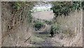
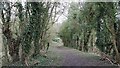
Bridleway leading from Longhedge Lane to Newboundmill Lane
The photograph shows the bottom of the bridleway just before it joins Newboundmill Lane.
To see another, more north-westerly photograph of the bridleway, click here:- Image
Image: © Alan Walker
Taken: 8 Mar 2017
0.08 miles
2
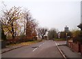
Newboundmill Lane in Pleasley
An assortment of signs indicating the narrowing of the road ahead and the exit from Pleasley.
Image: © Jonathan Clitheroe
Taken: 11 Nov 2011
0.09 miles
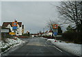
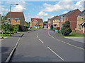
4
Newboundmill Lane
Looking in a north-easterly direction along Newboundmill Lane from a viewpoint near its junction with Terrace Lane.
Image: © Alan Walker
Taken: 8 Mar 2017
0.10 miles
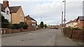
5
Parthenon Close
The back entrance to Pleasley Pit had some 1870s colliery housing here, which have been replaced by this housing estate since 2000.
Image: © Trevor Rickard
Taken: 11 Jun 2011
0.13 miles
6
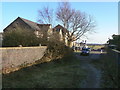
Terrace Lane
Modern housing has replaced much of the older stock provided as miners' housing. The lane narrows to a footpath to cross the bridge over the former railway line to give access to Pleasley Country Park.
Image: © Alan Murray-Rust
Taken: 31 Jan 2010
0.14 miles
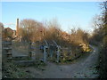
7
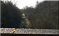
Teversal Trail
View from the bridge seen in http://www.geograph.org.uk/photo/1688503.
Image: © Alan Murray-Rust
Taken: 31 Jan 2010
0.14 miles
8
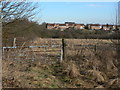
View towards Upper Pleasley
In the distance modern housing development at the west end of Pleasley.
Image: © Alan Murray-Rust
Taken: 31 Jan 2010
0.15 miles
9
Bridleway leading from Longhedge Lane to Newboundmill Lane
Image is behind the viewpoint and Newboundmill Lane is ahead.
Image: © Alan Walker
Taken: 8 Mar 2017
0.16 miles
10
Trail junction
Part of the network of paths based on Pleasley Country Park. The footpath to the right runs along the top of an old railway cutting which is now the Teversal Trail.
Image: © Alan Murray-Rust
Taken: 31 Jan 2010
0.16 miles