IMAGES TAKEN NEAR TO
Radmanthwaite Lane, MANSFIELD, NG19 7RU
Introduction
This page details the photographs taken nearby to Radmanthwaite Lane, NG19 7RU by members of the Geograph project.
The Geograph project started in 2005 with the aim of publishing, organising and preserving representative images for every square kilometre of Great Britain, Ireland and the Isle of Man.

There are currently over 7.5m images from over14,400 individuals and you can help contribute to the project by visiting https://www.geograph.org.uk
Image Map
Images are licensed for reuse under creativecommons.org/licenses/by-sa/2.0
Notes
- Clicking on the map will re-center to the selected point.
- The higher the marker number, the further away the image location is from the centre of the postcode.
Image Listing (61 Images Found)
Images are licensed for reuse under creativecommons.org/licenses/by-sa/2.0
Image
Details
Distance
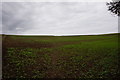
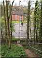
3
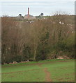
Pleasley NG19, Near Mansfield, Notts.
This footpath continues into the copse ahead and very quickly links to the top of a flight of steps descending down an embankment to reach the side of the A617 Road (Chesterfield Road North), opposite the junction with the 'old' Chesterfield Road junction and The White Swan pub. Behind the photographer the footpath continues across the ploughed field and a couple of minutes later it joins a track that connects the Pleasley end of Woburn Lane, Pleasley Hill with a private residence called Radmanthwaite Cottage at the termination of the lane. This arable land seems likely to belong to Wren Hill Farm, Lower Radmanthwaite. The name Radmanthwaite is derived from two words, a radman being a tenant owing his lord the duty of an armed escort + thwaite being a clearing in a wood or land reclaimed for arable purposes. In the distance is the former Pleasley Colliery that ceased to produce coal in the 1980s.
Image: © David Hallam-Jones
Taken: 28 Apr 2013
0.16 miles
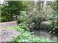
4
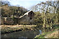
Old Building
Use unknown, see in Meden Trail Nature Reserve
Image: © Ashley Dace
Taken: 24 Feb 2011
0.16 miles
5
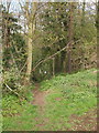
Pleasley NG19, Near Mansfield, Notts.
This unmade footpath, most of which is behind the photographer, continues into the copse and within 50 yards or so links to the top of a flight of concrete steps that drop down an embankment to reach the pavement at the side of the A617 (Chesterfield Road North) opposite the junction with the 'old' Chesterfield Road and The White Swan pub. To the rear of the photographer this footpath crosses a ploughed field and joins up with a track that connects the Pleasley end of Woburn Lane, Pleasley Hill with Radmanthwaite Cottage - a private residence - that is situated at its south-westerly termination. The word Radmanthwaite is derived from two words, a radman being a tenant owing his lord the duty of an armed escort + thwaite, being a clearing in a wood or land reclaimed for arable purposes.
Image: © David Hallam-Jones
Taken: 28 Apr 2013
0.16 miles
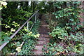
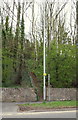
6
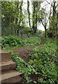
Pleasley NG19, Near Mansfield, Notts.
The foot of this flight of steps is on the side of the A117 Road (Chesterfield Road North) opposite the 'old' Chesterfield Road junction (obliquely opposite The White Swan pub). Ahead is the start (or end) of a footpath that crosses a ploughed field and joins up with a track from the Pleasley end of Woburn Lane, Pleasley Hill, with a private residence called Radmanthwaite Cottage situated at the termination of the lane. The word Radmanthwaite seems to be derived from two words, a radman being a tenant who owed his lord the duty of an armed escort + thwaite being a clearing in a wood or land reclaimed for arable purposes.
Image: © David Hallam-Jones
Taken: 28 Apr 2013
0.16 miles
7
Pleasley NG19, Near Mansfield Notts.
The 'old' Chesterfield Road can be seen branching off the A617 (Chesterfield Road North) at the foot of this flight of steps. Behind the photographer an unmade footpath continues to the top of this bank and joins the start (or end) of a footpath that obliquely crosses a ploughed field and to link with a track that connects the Pleasley end of Woburn Lane, Pleasley Hill with a private residence called Radmanthwaite Cottage situated at the termination of this lane. The word Radmanthwaite seems to be derived from two words, a radman being a tenant who owed his lord the duty of an armed escort + thwaite being a clearing in a wood or land reclaimed for arable purposes.
Image: © David Hallam-Jones
Taken: 28 Apr 2013
0.16 miles
8
Pleasley NG19, Near Mansfield, Notts.
This flight of steps on the opposite side of the A117 Road (Chesterfield Road North) to the corner that is occupied by The White Swan pub leads up to the start (or end) of a footpath that obliquely crosses a ploughed field and joins up with a track from the Pleasley end of Woburn Lane, Pleasley Hill, with a private residence called Radmanthwaite Cottage situated at the termination of this lane. The word Radmanthwaite seems to be derived from two words, a radman being a tenant who owed his lord the duty of an armed escort + thwaite being a clearing in a wood or land reclaimed for arable purposes.
Image: © David Hallam-Jones
Taken: 28 Apr 2013
0.16 miles