IMAGES TAKEN NEAR TO
Newport Crescent, MANSFIELD, NG19 6BY
Introduction
This page details the photographs taken nearby to Newport Crescent, NG19 6BY by members of the Geograph project.
The Geograph project started in 2005 with the aim of publishing, organising and preserving representative images for every square kilometre of Great Britain, Ireland and the Isle of Man.

There are currently over 7.5m images from over14,400 individuals and you can help contribute to the project by visiting https://www.geograph.org.uk
Image Map
Images are licensed for reuse under creativecommons.org/licenses/by-sa/2.0
Notes
- Clicking on the map will re-center to the selected point.
- The higher the marker number, the further away the image location is from the centre of the postcode.
Image Listing (19 Images Found)
Images are licensed for reuse under creativecommons.org/licenses/by-sa/2.0
Image
Details
Distance
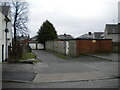
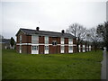
2
Collingham Road, Mansfield
Leading to a bevy of bungalows off Westfield Lane.
Image: © Richard Vince
Taken: 12 Dec 2020
0.16 miles
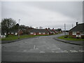
5
Low rise flats off Abbott Road, Mansfield
Image: © Richard Vince
Taken: 12 Dec 2020
0.17 miles

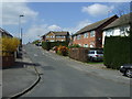
7
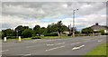
Junction of Water Lane and Abbott Road, Mansfield
Water Lane originally joined Abbott Lane just a few yards to the north of this point. The house on the corner has signs on both sides of the drive that look like standard road signs, saying Old Water Lane. Presumably because it seems to be on Abbott Road.
Image: © Chris Morgan
Taken: 12 Jun 2017
0.17 miles
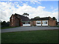
8
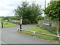
Old Water Lane
'New' Water Lane is a few yards to the left, the old lane now providing gated access to a private house but having retained its street signs.
Image: © Graham Hogg
Taken: 12 Jun 2017
0.19 miles
9
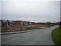
New housing south of Water Lane, Bull Farm
Many of the houses on this development appear to be occupied, even though the infrastructure is still under construction. Like a lot of housing developments of recent years, this one seems to have been designed to be as separate as possible from the existing housing in the area.
Image: © Richard Vince
Taken: 12 Dec 2020
0.19 miles
