IMAGES TAKEN NEAR TO
Mercury Way, MANSFIELD, NG18 6AR
Introduction
This page details the photographs taken nearby to Mercury Way, NG18 6AR by members of the Geograph project.
The Geograph project started in 2005 with the aim of publishing, organising and preserving representative images for every square kilometre of Great Britain, Ireland and the Isle of Man.

There are currently over 7.5m images from over14,400 individuals and you can help contribute to the project by visiting https://www.geograph.org.uk
Image Map
Images are licensed for reuse under creativecommons.org/licenses/by-sa/2.0
Notes
- Clicking on the map will re-center to the selected point.
- The higher the marker number, the further away the image location is from the centre of the postcode.
Image Listing (18 Images Found)
Images are licensed for reuse under creativecommons.org/licenses/by-sa/2.0
Image
Details
Distance
1
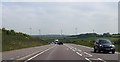
Bend on A617 near Firs Farm
Lindhurst Wind Farm ahead
Image: © John Firth
Taken: 9 Jun 2013
0.07 miles
3
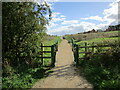
Footpath to Lindhurst Way West
Lindhurst Way West is the spine road of a large new housing development on the southern edge of Mansfield.
Image: © Jonathan Thacker
Taken: 1 Oct 2022
0.15 miles
4
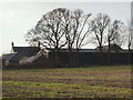
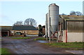
Black Scotch Lane, Mansfield, Notts.
Firs Farm is seen here from the south section of Black Scotch Lane, i.e. the part of Black Scotch Lane south of the A617, a road that has for a number of years (number unknown) bisected this lane 150 yards ahead.
Image: © David Hallam-Jones
Taken: 11 Jan 2015
0.16 miles
5
Black Scotch Lane, Mansfield, Notts.
The entrance to Firs Farm at the side of the southern section of Black Scotch Lane, i.e. south of the A617, a road that bisects this lane about 50 yards to the left.
Image: © David Hallam-Jones
Taken: 11 Jan 2015
0.17 miles
6
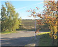
Old Newark Road
on the southern edge of Mansfield, it's now just a dirt track and cannot be used by vehicles
Image: © Tom Courtney
Taken: 9 Oct 2005
0.18 miles
7
Chatsworth Drive, Mansfield, Notts.
A south-facing off-shot section of Chatsworth Drive reveals arable land belonging to Fir's Farm on the other side of a section of the former Old Newark Road.
Image: © David Hallam-Jones
Taken: 10 Nov 2013
0.20 miles
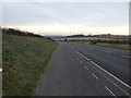
8
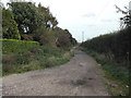
Black Scotch Lane
Track heading north from the A617.
Image: © JThomas
Taken: 17 Mar 2014
0.20 miles
9
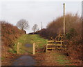
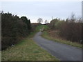
Black Scotch Lane, Mansfield, Notts.
The path and bridleway ahead leads users past Firs Farm and terminates when it reaches a T junction with a footpath that follows the course of the Old Newark Road. These bollards obviously exist to prevent most motor vehicles from entering or exiting this southern section of Black Scotch Lane. The northern section of the lane continues behind the photographer on the other side of the A617 road.
Image: © David Hallam-Jones
Taken: 11 Jan 2015
0.20 miles
10
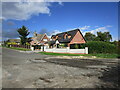
Housing, Chatsworth Drive
Picture taken from Old Newark Road.
Image: © Jonathan Thacker
Taken: 1 Oct 2022
0.20 miles