1
Mansfield - Whiteleys Mill
On Victoria Street.
Image: © Dave Bevis
Taken: 1 Jan 2007
0.05 miles
2
Victoria Street, Mansfield, Notts.
The Salvation Army Church Centre situated on the side of a T junction formed by Victoria St (i.e. behind the photographer and ahead too) with Tenter Street branching off to the left. As well as home to traditional facilities, i.e its Citadel and hall, it is also an accredited Contact Centre where estranged parents can have supervised periodic contact with a parent.
Image: © David Hallam-Jones
Taken: 20 Jan 2016
0.07 miles
3
Victoria Street, Mansfield, Notts.
Victoria Street, looking towards Rooth Street. Victoria Street is home, amongst other businesses, to the Victoria Antiques and Collectables Centre.
Image: © David Hallam-Jones
Taken: 20 Jan 2016
0.07 miles
4
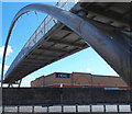
Footbridge to Shops
Close to Mansfield railway station, the pedestrian bridge over the inner ring road. It links the old town centre with the new shopping area next to the football ground.
Image: © Peter Kochut
Taken: 26 May 2005
0.08 miles
5
Mansfield - Primitive Methodist Centenary Hall
On Victoria Street.
Image: © Dave Bevis
Taken: 14 Apr 2011
0.09 miles
6
Corner of Tenter Street and Princess Street, Mansfield
This corner house must have a story to tell.
Image: © Chris Morgan
Taken: 31 Mar 2014
0.10 miles
7
Dallas Street, Mansfield, Notts.
Dallas Street curves round from the left, passes this Spiritualist Church, and within a minute's walk joins the busy A38 (a.k.a. Stockwell Gate) at a T junction.
Image: © David Hallam-Jones
Taken: 20 Jan 2016
0.10 miles
8
Portland Street, Mansfield, Notts.
The 280-tonne futuristic Gateway Bridge was installed place in the autumn of 2001. The £600,000 footbridge stretches 40 metres over this inner ring road and acts as the centrepiece of a major environmental improvement project that saw the transformation of the previously rundown Belvedere Street, Portland Street and Stockwell Gate area. Prior to the opening of the bridge, pedestrians and cyclists had to negotiate a six-lane carriageway to get access to the “Portland Sidings Retail Park” and the football ground. The footbridge links the Portland Sidings shopping area behind the photographer with the town centre and St Peter’s Retail Park ahead.
Image: © David Hallam-Jones
Taken: 17 Apr 2016
0.10 miles
9
Portland Street, Mansfield, Notts.
The 280-tonne futuristic Gateway Bridge was put into place in the autumn of 2001. The footbridge, that cost £600,000, stretches 40 metres over this inner ring road and acts as the centrepiece of a major environmental improvement project that saw the transformation of the previously rundown Belvedere Street, Portland Street and Stockwell Gate area. Prior to the opening of the bridge, pedestrians and cyclists had to negotiate a multi-lane carriageway to access the “Portland Sidings Retail Park” and the football ground. The footbridge links the Portland Sidings shopping area on the left with the town centre and St Peter’s Retail Park on the right.
Image: © David Hallam-Jones
Taken: 17 Apr 2016
0.12 miles
10
Portland Street, Mansfield, Notts.
The Belvedere Street/Portland Street railway bridge seen here carries rail traffic on the Robin Hood Line in and out of Mansfield Station. Apart from the stone steps that pedestrians can use between the elevated station and the southbound side of the carriageway, a section of the futuristic Gateway footbridge - from which this photo was taken - can be seen in front of the TK Maxx retail outlet. Gateway Bridge links the Portland Sidings Retail Park (behind the photographer) with the town centre (on the right).
Image: © David Hallam-Jones
Taken: 17 Apr 2016
0.12 miles


