IMAGES TAKEN NEAR TO
Victoria Court, MANSFIELD, NG18 5SP
Introduction
This page details the photographs taken nearby to Victoria Court, NG18 5SP by members of the Geograph project.
The Geograph project started in 2005 with the aim of publishing, organising and preserving representative images for every square kilometre of Great Britain, Ireland and the Isle of Man.

There are currently over 7.5m images from over14,400 individuals and you can help contribute to the project by visiting https://www.geograph.org.uk
Image Map
Images are licensed for reuse under creativecommons.org/licenses/by-sa/2.0
Notes
- Clicking on the map will re-center to the selected point.
- The higher the marker number, the further away the image location is from the centre of the postcode.
Image Listing (29 Images Found)
Images are licensed for reuse under creativecommons.org/licenses/by-sa/2.0
Image
Details
Distance

3
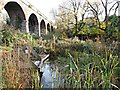
Drury Dam Viaduct, Mansfield, Notts.
The Grade II-listed Drury Dam Viaduct was named after a Mansfield flour mill owner, Daniel Drury. It was built in 1875 and originally carried a spur of the Midland Railway Company’s Southwell-Mansfield line over the Maun Valley between Mansfield's East and South junctions. The line first carried traffic on 3rd April 1871, although the section over the viaduct was closed in October 1872, only to reopen again on 28th January 1906. The route continued to carry coal traffic from Rufford Colliery until 12th December 1983. At this end of it, i.e. its western end, a single cast-iron skew span with four rib arches with pierced spandrels and a panelled iron parapet, form part of the viaduct carrying the viaduct over Quarry Lane. The viaduct was restored in 1989 and now carries walkers and cyclists over the River Maun on this section of the Maun Valley Trail. The town centre lies ahead, a 15-20 minute walk away.
Image: © David Hallam-Jones
Taken: 19 Nov 2017
0.16 miles
4
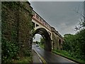
Drury Dam Railway Viaduct, Mansfield
Completed in 1875, the viaduct no longer carries trains. It was restored in 1989 and now supports a leisure footpath.
Image: © Neil Theasby
Taken: 20 Jul 2019
0.17 miles
5
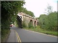
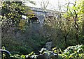
Drury Viaduct, Quarry Lane, Mansfield
Built in the 1870's to carry a mineral railway line over Quarry Lane and the River Maun, Drury Viaduct was named after Drury's Flour Mill, which stood nearby. It is now a foot and cycle path.
Image: © Antony Dixon
Taken: 23 Aug 2011
0.17 miles
6
Quarry Lane Nature Reserve, Mansfield, Notts.
Quarry Mill Viaduct and "The Scrape" wildlife area. In 2004 this area was dredged and redeveloped to provide a pond dipping area for local children. The Grade II-listed Drury Dam Viaduct was named after a Mansfield flour mill owner, Daniel Drury. It was built in 1875. It originally carried a spur of the Midland Railway Company’s Southwell-Mansfield line over the Maun Valley between Mansfield's East and South junctions. The line first carried traffic on 3rd April 1871, although the section over the viaduct was closed in October 1872, only to reopen again on 28th January 1906. The route continued to carry coal traffic from Rufford Colliery until 12th December 1983. The viaduct It was restored in 1989 and now forms part of the town’s Maun trail.
Image: © David Hallam-Jones
Taken: 19 Nov 2017
0.17 miles
7
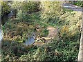
The Scrape, Quarry Lane Reserve, Mansfield, Notts.
"The Scrape" wildlife area. In 2004 this area, adjoining the River Maun, was dredged and redeveloped to provide a pond dipping area for local children. This photo is taken looking down from the Grade II-listed Drury Dam Viaduct. The viaduct It was restored in 1989 and now forms part of the town’s Maun trail.
Image: © David Hallam-Jones
Taken: 19 Nov 2017
0.17 miles
8
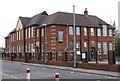
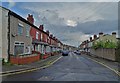
Mansfield - Sutton Road Primary School
On Moor Lane.
Image: © Dave Bevis
Taken: 14 Apr 2011
0.18 miles
9
Drury's Dam Viaduct, Mansfield, Notts.
The River Maun, heading in the direction of the town centre, is seen from a footbridge in Quarry Lane Local Nature Reserve. The footbridge, atop a former sluice gate, carries the Timberland Trail across the river. The Timberland Trail starts at Kingsmill Reservoir and follows a route around the southern edge of the town centre, joining the Mansfield Way at Racecourse Road. This walking and cycling path joins the route formerly followed by the Mansfield - Southwell railway line at Fisher Lane Park. It is also possible to exit this nature reserve a stone’s throw from this footbridge and to join Quarry Lane, a road that runs past the town’s football stadium. The Maun Valley Trail is carried across the river and this nature reserve by the viaduct.
Image: © David Hallam-Jones
Taken: 19 Nov 2017
0.18 miles
10
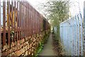
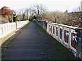
Between railway and industry
A candidate for one of the country's ugliest footpaths?
Image: © Graham Hogg
Taken: 31 Mar 2014
0.18 miles