IMAGES TAKEN NEAR TO
Lichfield Lane, MANSFIELD, NG18 4RD
Introduction
This page details the photographs taken nearby to Lichfield Lane, NG18 4RD by members of the Geograph project.
The Geograph project started in 2005 with the aim of publishing, organising and preserving representative images for every square kilometre of Great Britain, Ireland and the Isle of Man.

There are currently over 7.5m images from over14,400 individuals and you can help contribute to the project by visiting https://www.geograph.org.uk
Image Map
Images are licensed for reuse under creativecommons.org/licenses/by-sa/2.0
Notes
- Clicking on the map will re-center to the selected point.
- The higher the marker number, the further away the image location is from the centre of the postcode.
Image Listing (25 Images Found)
Images are licensed for reuse under creativecommons.org/licenses/by-sa/2.0
Image
Details
Distance
1
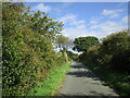
Old Newark Road, Mansfield, Notts.
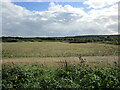
This gateway marks the last house at the side of this maintained section of the Old Newark Road, because within the next 100 yds it becomes an earth track. A quarter of a mile behind the photographer, Old Newark Road joins Lichfield Lane and then soon afterwards the latter joins the A60 (Mansfield-Nottingham) Road near to the West Notts College site. Four or so miles ahead, at the other end of this route - some sections of which are maintained, whilst others have been left as rough tracks - Old Newark Road joins the A6191 dual carriageway (a.k.a. Southwell Road West) near to the Three Thorn Hollow roundabout. Arable farmland belonging to Fir's Farm exists behind the hedgerow on the right.
Image: © David Hallam-Jones
Taken: 10 Nov 2013
0.07 miles
3
Old Newark Road, Mansfield, Notts.
This previously important connection between the south of Mansfield and the main route between Mansfield-Rainworth looks as though it has been relegated to a C or D category road and it seems to be a short-cut for local drivers. This is the view of one end of it (start or finish) off Lichfield Lane in the West Nottinghamshire College area of Mansfield, i.e. a stones's throw away from the Mansfield-Nottingham road (A60).
Image: © David Hallam-Jones
Taken: 16 Jun 2013
0.08 miles
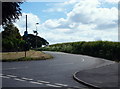
4
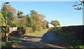
Old Newark Road, Mansfield, Notts.
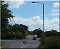
The start (or conclusion) of Old Newark Road at its junction with Lichfield Lane. Behind the pedestrian is the A60 (Turn left for Ravenshead and Nottingham or left for Mansfield). The car ascending the hill in the distance is on Cauldwell Road, a road that soon connects with the A611. Behind the photographer Old Newark Road connects this southern suburb of Mansfield with the A6191 (the Mansfield - Rainworth road). The West Nottinghamshire College is situated to the right of the traffic bollards that are on the right of the picture.
Image: © David Hallam-Jones
Taken: 16 Jun 2013
0.09 miles
5
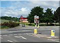
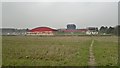
West Notts. College Area, Mansfield, Notts.
The car beginning its gentle ascent of Cauldwell Road (towards the A611) has just turned off the Nottingham to Mansfield Road (the A60). The centre of Mansfield is reached by taking a right-hand turning here. It seems likely that the red, biscuit and grey building in the picture is a gymnasium on the West Nottinghamshire College site. This picture was taken from Lichfield Lane.
Image: © David Hallam-Jones
Taken: 16 Jun 2013
0.13 miles
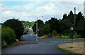
6
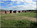
West Notts College Area, Mansfield.
This picture was taken from Cauldwell Road. The car is on Lichfield Lane with Old Newark Road a right-hand turning off it. The road travelling from left to right across the centre of the picture is the A60 (left for Mansfield town centre and right for Ravenshead and Nottingham). The Derby Road campus of the West Nottinghamshire College occupies a plot on the left , i.e. where the corner of the pavement is in the bottom left-hand corner.
Image: © David Hallam-Jones
Taken: 16 Jun 2013
0.14 miles
7
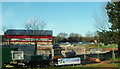
Nottingham Road, Mansfield.
Construction work on the "Vision West Nottinghamshire College" site. Cauldwell Lane, that passes the end of the gymnasium-style building on left hand margin of the picture, joins the A60 (the main Mansfield-Nottingham road) to the photographer's left.
Image: © David Hallam-Jones
Taken: 15 Jan 2016
0.16 miles