1
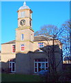
Berry Hill Lane, Mansfield, Notts.
The Grade II-listed former coach house and stable block of Berry Hill Hall on the south side of Berry Hill Lane. These formed part of a mid-late C18th country house with C19th and C20th additions. The south front has a square tower with an octagonal 2-storey cupola topped with a leaded ogee cap and clock faces to each of its four sides. In 1924 the premises were opened as a miners’ convalescent home by Mr. John Bingley. Later, between 1953-1990, it was owned and managed by the NHS. Most of the site, including the Hall (not visible here) has been converted into luxury apartments, although this process appears unfinished. To the left of the car, beyond fences and notices warning of "steep cliffs", lies a redundant quarry that now houses modern housing. The A60 (the main Mansfield-Nottingham road) lies 10 minutes walk away, behind the photographer.
Image: © David Hallam-Jones
Taken: 15 Jan 2016
0.01 miles
2
Berry Hill Hall, Mansfield, Notts.
Part of the Grade II-listed former Berry Hill Hall. This protruding square tower on the south elevation of the stable block features an octagonal two-storey cupola topped with a leaded ogee cap. The stables and adjacent farm courtyard formed part of what was once a mid-late C18th country house. In 1924 the Hall was opened as a miners’ convalescent home by Mr. John Bingley. Later on, between 1953-1990, it was owned and managed by the NHS. Other parts of the site are still in the process of being converted into luxury apartments.
Image: © David Hallam-Jones
Taken: 15 Jan 2016
0.02 miles
3
Berry Hill Lane, Mansfield, Notts.
The Grade II-listed former coach house and stable block of Berry Hill Hall on the south side of Berry Hill Lane. These formed part of a mid-late C18th country house with C19th and C20th additions. The south front features a square tower with an octagonal 2-storey cupola topped with a leaded ogee cap and clock faces to each of its four sides. In 1924 the premises were opened as a miners’ convalescent home by Mr. John Bingley. Later, between 1953-1990, it was owned and managed by the NHS. The last part of the site, including the Hall (not visible here) is in the process of being converted into luxury apartments. To the right of the oncoming car and beyond fences and notices warning of "steep cliffs", lies a redundant quarry that now houses a modern housing development. The A60 (the main Mansfield-Nottingham road) lies 10 minutes walk ahead.
Image: © David Hallam-Jones
Taken: 15 Jan 2016
0.04 miles
4
Mansfield - Berry Hill Hall Coach House
See
Image for the history of the Hall.
Image: © Dave Bevis
Taken: 14 Dec 2010
0.05 miles
5
Berry Hill Lane, Mansfield, Notts.
This wing, on the west side of the Grade II-listed former Berry Hill Hall, is seen from Berry Hill Lane. It formed part of a mid-late C18th country house but has C19th and C20th additions. In 1924 the premises were opened as a miners’ convalescent home by Mr. John Bingley. Later on, between 1953-1990, it was owned and managed by the NHS. Parts of the site are still in the process of being converted into luxury apartments. Berry Hill Park, at the rear of this residential complex, can be reached via a pedestrian gate to the photographer's left. The A60 (the main Mansfield-Nottingham road) is a 10 minutes walk away on the photographer's right.
Image: © David Hallam-Jones
Taken: 15 Jan 2016
0.05 miles
6
Mansfield - Berry Hill Hall
An early 18th century country house, with large scale additions built for William Bilbie in around 1770. A new south wing was added in the early 19th century, with a central pediment. Further additions were made in the 19th and mid 20th century. The building was used until about 1990 as a miners' rehabilitation centre. The Hall subsequently fell into disrepair, but is now (2010) being converted into apartments. See also http://www.nottinghamshire.gov.uk/bar-mansfield.pdf.
Image: © Dave Bevis
Taken: 14 Dec 2010
0.06 miles
7
Berry Hill Hall, Mansfield, Notts.
A section of the Grade II-listed former Berry Hill Hall. This part of the Hall, built for William Bilbie, has been dated to c.1770. In 1924 the Hall was opened as a miners’ convalescent home by Mr. John Bingley. Later on, between 1953-1990, it was owned and managed by the NHS. Other parts of the site are still in the process of being converted into luxury apartments. Behind the photographer lies Berry Hill Park.
Image: © David Hallam-Jones
Taken: 15 Jan 2016
0.07 miles
8
Radio Mast Mansfield
Berry Hill Park
Image: © norman griffin
Taken: 9 Feb 2018
0.08 miles
9
Former Berry Hill Hospital
Now apartments.
Image: © Jonathan Thacker
Taken: 13 Jan 2022
0.08 miles
10
Berry Hill Lane, Mansfield, Notts.
A private house with a lodge-style appearance situated between a driveway entrance to the former Berry Hill Hall and "The Coal Industry Social Welfare Organisation" (CISWO) premises beyond it. Berry Hill Park is situated behind the rear boundary wall of this property and it can be accessed by on foot via a gate to the photographer's right, i.e. at the side of Berry Hill Hall.
Image: © David Hallam-Jones
Taken: 15 Jan 2016
0.09 miles


