IMAGES TAKEN NEAR TO
Delamere Drive, MANSFIELD, NG18 4DF
Introduction
This page details the photographs taken nearby to Delamere Drive, NG18 4DF by members of the Geograph project.
The Geograph project started in 2005 with the aim of publishing, organising and preserving representative images for every square kilometre of Great Britain, Ireland and the Isle of Man.

There are currently over 7.5m images from over14,400 individuals and you can help contribute to the project by visiting https://www.geograph.org.uk
Image Map
Images are licensed for reuse under creativecommons.org/licenses/by-sa/2.0
Notes
- Clicking on the map will re-center to the selected point.
- The higher the marker number, the further away the image location is from the centre of the postcode.
Image Listing (6 Images Found)
Images are licensed for reuse under creativecommons.org/licenses/by-sa/2.0
Image
Details
Distance
1
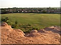
Forest Road Recreation Ground
A sandstone outcrop off Berry Hill Road, then the rec and some houses built in the 1970s and 80s.
Much of this area was formerly a sand quarry, closed many years ago.
Image: © Peter Kochut
Taken: 27 Jun 2005
0.10 miles
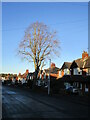
3
New houses on Berry Hill Sand Quarry site
Much of Mansfield is built on sandstone. It has been quarried for many years and used for moulds in ironfounding. Together with locally available coal this was the basis of several former ironfoundries in the town. This quarry, now closed is being used for new housing.
In the 1960s I remember walking here, along a public footpath through a field of wheat or barley, before the quarrying dug so deeply.
Image: © Peter Kochut
Taken: 27 Jun 2005
0.18 miles
4
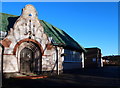
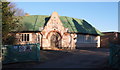
Sandhurst Avenue, Mansfield, Notts.
Detail of the 'Dutch Cape' style entrance into the Mansfield Sand Company's combined gatekeeper's lodge and office. The date of construction and who the architect was are unknown at present. The houses in the distance, i.e. on the other side of the quarry seem likely to be situated on Berry Hill Road.
Image: © David Hallam-Jones
Taken: 15 Jan 2016
0.18 miles
5
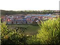
Sandhurst Avenue, Mansfield, Notts.
The entrance to the Mansfield Sand Company's premises (formerly Gregory's Quarry ?) at the Berry Hill Lane end of Sandhurst Avenue. This is a view of the combined gatekeeper's lodge and office. Sand from this quarry was reputed to be the finest in the UK and was used extensively in both local foundries and those further afield.
Image: © David Hallam-Jones
Taken: 15 Jan 2016
0.18 miles
6
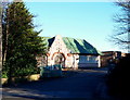
Sandhurst Avenue, Mansfield, Notts.
The entrance to the Mansfield Sand Company's premises at the Berry Hill Lane end of Sandhurst Avenue. This is a view of the combined gatekeeper's lodge and office. Sand from this quarry was reputed to be the finest in the UK and was used extensively in both local foundries and those further afield.
Image: © David Hallam-Jones
Taken: 15 Jan 2016
0.20 miles