IMAGES TAKEN NEAR TO
Tideswell Court, MANSFIELD, NG18 2PD
Introduction
This page details the photographs taken nearby to Tideswell Court, NG18 2PD by members of the Geograph project.
The Geograph project started in 2005 with the aim of publishing, organising and preserving representative images for every square kilometre of Great Britain, Ireland and the Isle of Man.

There are currently over 7.5m images from over14,400 individuals and you can help contribute to the project by visiting https://www.geograph.org.uk
Image Map
Images are licensed for reuse under creativecommons.org/licenses/by-sa/2.0
Notes
- Clicking on the map will re-center to the selected point.
- The higher the marker number, the further away the image location is from the centre of the postcode.
Image Listing (27 Images Found)
Images are licensed for reuse under creativecommons.org/licenses/by-sa/2.0
Image
Details
Distance
1
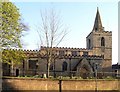
Saint Peter's Church, Mansfield
The parish church of St. Peter and St. Paul, Mansfield town centre. Constructed and modified during a period of several hundred years, parts of the building date from Norman times, mostly it is somewhat more recent. The two small narrow windows in the lower part of the church tower are a Norman feature, there is also a typically Norman rounded arch in the doorway (not visible here).
Image: © Peter Kochut
Taken: 11 Apr 2005
0.13 miles
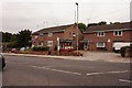
2
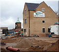
Recreation Road Vicinity, Mansfield, Notts.
BMA Ltd of Tuxford, Newark are in the process of building 14 residential properties on a plot of land sandwiched between the rear gardens (or backyards) of the existing terraced houses on Recreation Road and the tower in the distance. St Peter's Way (i.e. the A60/A6006) passes between the tower - situated in a former quarry known as Rock Valley - and one side of a natural rock embankment 75 metres behind this new house. The entrance to this small new-build development will be behind where the photographer was standing. The domed clocktower is the only structure remaining on the former Metal Box Company factory site in the former quarry in question.
Image: © David Hallam-Jones
Taken: 7 Feb 2016
0.18 miles
4

Rock Valley
This photo shows the rock formation which gives Rock Valley its name. This view was hidden for over a hundred years by the Barringer, Wallis and Manners (later Metal Box) works. No doubt it will disappear again when the site (which is now up for sale) is redeveloped.
Image: © Antony Dixon
Taken: 2 Aug 2013
0.19 miles
5

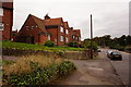
Recreation Street, Mansfield
Early 20th century terraced housing development from the industrial expansion of the town.
Image: © Alan Murray-Rust
Taken: 21 Aug 2019
0.20 miles
6

Rock Valley
Seen from St Peter's Way. Only visible since the demolition of the former Metal Box works.
Image: © JThomas
Taken: 16 Mar 2014
0.20 miles
7
Mansfield - Crown Packaging Factory
On Rock Valley.
Image: © Dave Bevis
Taken: 9 Jul 2009
0.20 miles
9

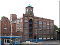
Metal Box Clock Tower, Mansfield
The clock tower belonged to the old Metal Box factory in Rock Valley which was demolished in 2011. After a campaign, the decision was taken to preserve the old tower and incorporate it into future developments. At the moment, however, it stands forlorn by St Peter's Way. For a view of how things were see: Image
Image: © Stephen McKay
Taken: 23 Jul 2016
0.21 miles
10
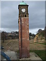
Clocktower, former Metal Box works, Rock Valley
All that remains of the works in Rock Valley.
Image: © JThomas
Taken: 16 Mar 2014
0.21 miles