IMAGES TAKEN NEAR TO
Newgate Lane, MANSFIELD, NG18 2LQ
Introduction
This page details the photographs taken nearby to Newgate Lane, NG18 2LQ by members of the Geograph project.
The Geograph project started in 2005 with the aim of publishing, organising and preserving representative images for every square kilometre of Great Britain, Ireland and the Isle of Man.

There are currently over 7.5m images from over14,400 individuals and you can help contribute to the project by visiting https://www.geograph.org.uk
Image Map
Images are licensed for reuse under creativecommons.org/licenses/by-sa/2.0
Notes
- Clicking on the map will re-center to the selected point.
- The higher the marker number, the further away the image location is from the centre of the postcode.
Image Listing (18 Images Found)
Images are licensed for reuse under creativecommons.org/licenses/by-sa/2.0
Image
Details
Distance
1
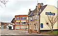
Ratcliffe Gate, Mansfield, Notts.
The Kings Arms public house is seen dominating this corner site at its junction with Newgate Street. The town centre lies ahead. After a spell in Newgate Lane, in 1914 Mansfield Town Football Club moved to a large grassed area south of Ratcliffe Gate, that gloried in the name of "The Prairie" due to this being a wide open space.
Image: © David Hallam-Jones
Taken: 7 Feb 2016
0.18 miles
2

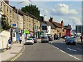
Ratcliffe Gate, Mansfield
A substantial area of yellow hatching marks the junction between Ratcliffe Gate (A6191), Great Central Road (leading off to the right in the foreground), and Newgate Lane (opposite). The 'Great Central Road' name is a reminder of Mansfield's largely forgotten 'other' railway that passed over Ratcliffe Gate here; it was closed completely in 1966 and little trace now remains.
Image: © Stephen McKay
Taken: 23 Jul 2016
0.19 miles
3

The Brown Cow - pub garden
A pleasant space to enjoy a drink and relax - especially on a sunny day. The pub is located on Ratcliffe Gate.
Image: © Stephen McKay
Taken: 23 Jul 2016
0.19 miles
4

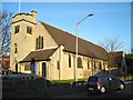
St. Lawrence's Hall, Mansfield
Church hall.
Image: © Jonathan Thacker
Taken: 13 Jan 2022
0.20 miles
5

Ratcliffe Gate, Mansfield
The Brown Cow is an Everards pub offering a range of cask ales from Everards and other breweries. There is a pleasant beer garden at the rear. Ratcliffe Gate is part of the A6191.
Image: © Stephen McKay
Taken: 23 Jul 2016
0.20 miles
6

Shop and houses, Skerry Hill, Mansfield
Image: © Jonathan Thacker
Taken: 13 Jan 2022
0.20 miles
9
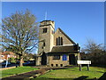
Church of St. Lawrence, Mansfield
Designed by Robert Frank Valance and Louis Alfred Westwick 1908-9 https://southwellchurches.nottingham.ac.uk/mansfield-st-lawrence/hhistory.php
Image: © Jonathan Thacker
Taken: 13 Jan 2022
0.22 miles
10

Recreation Street, Mansfield
Early 20th century terraced housing development from the industrial expansion of the town.
Image: © Alan Murray-Rust
Taken: 21 Aug 2019
0.23 miles