IMAGES TAKEN NEAR TO
Prospect Street, MANSFIELD, NG18 2JJ
Introduction
This page details the photographs taken nearby to Prospect Street, NG18 2JJ by members of the Geograph project.
The Geograph project started in 2005 with the aim of publishing, organising and preserving representative images for every square kilometre of Great Britain, Ireland and the Isle of Man.

There are currently over 7.5m images from over14,400 individuals and you can help contribute to the project by visiting https://www.geograph.org.uk
Image Map
Images are licensed for reuse under creativecommons.org/licenses/by-sa/2.0
Notes
- Clicking on the map will re-center to the selected point.
- The higher the marker number, the further away the image location is from the centre of the postcode.
Image Listing (13 Images Found)
Images are licensed for reuse under creativecommons.org/licenses/by-sa/2.0
Image
Details
Distance
1
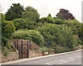
Rock Hill, Mansfield, Notts.
It seems that John Bramwell (1815-1900) was the last person to live in any of the cave houses in this sandstone outcrop. Most of his adult life was spent living in a cave-house here. He and his wife Sarah had raised 10 children, all of whom were born in his abode. Only one had died during infancy and all of the others apparently survived into old age.
Image: © David Hallam-Jones
Taken: 16 Jul 2017
0.11 miles
2
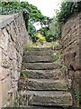
Rock Hill, Mansfield, Notts.
Steps leading from pavement level of Rock Hill (< street name) to one of the upper levels where "rock house dwellers" lived until the late 1800s.
Image: © David Hallam-Jones
Taken: 16 Jul 2017
0.13 miles
3
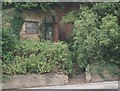
Rock Hill, Mansfield, Notts.
It seems that John Bramwell (1815-1900) was the last person to live in any of the cave dwellings. Most of his adult life was spent living in a sandstone cave-house here. He and his wife Sarah had raised 10 children, all of whom were born in his abode. Only one had died during infancy and all of the others apparently survived into old age.
Image: © David Hallam-Jones
Taken: 16 Jul 2017
0.13 miles
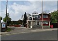
5
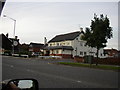
Ratcliffe Gate, Mansfield, Notts.
The Kings Arms public house is seen dominating this corner site at its junction with Newgate Street. The town centre lies ahead. After a spell in Newgate Lane, in 1914 Mansfield Town Football Club moved to a large grassed area south of Ratcliffe Gate, that gloried in the name of "The Prairie" due to this being a wide open space.
Image: © David Hallam-Jones
Taken: 7 Feb 2016
0.18 miles
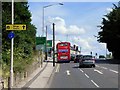
7

Ratcliffe Gate, Mansfield
A substantial area of yellow hatching marks the junction between Ratcliffe Gate (A6191), Great Central Road (leading off to the right in the foreground), and Newgate Lane (opposite). The 'Great Central Road' name is a reminder of Mansfield's largely forgotten 'other' railway that passed over Ratcliffe Gate here; it was closed completely in 1966 and little trace now remains.
Image: © Stephen McKay
Taken: 23 Jul 2016
0.19 miles
8
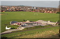
Fisher Lane Park, Mansfield, Notts.
Mansfield's Skate Plaza, that opened on December 2009, represents a relatively new concept (the first one having been built in the USA in 2005). A Skate Plaza is designed to recreate the urban street environment which many riders and skaters enjoy that uses materials that are commonly found in urban environments e.g. granite marble which is good for grinding and sliding. This one is seen from a flight of steps plus a footpath that descends from Windsor Road and links to Fisher Lane. This point on Windsor Road is also where The Timberland Trail and the Mansfield Trail cross. Other parts of Mansfield feature in the distance.
Image: © David Hallam-Jones
Taken: 11 Jan 2015
0.22 miles
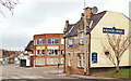
9

Ratcliffe Gate, Mansfield
The Brown Cow is an Everards pub offering a range of cask ales from Everards and other breweries. There is a pleasant beer garden at the rear. Ratcliffe Gate is part of the A6191.
Image: © Stephen McKay
Taken: 23 Jul 2016
0.22 miles