IMAGES TAKEN NEAR TO
Quaker Way, MANSFIELD, NG18 1JJ
Introduction
This page details the photographs taken nearby to Quaker Way, NG18 1JJ by members of the Geograph project.
The Geograph project started in 2005 with the aim of publishing, organising and preserving representative images for every square kilometre of Great Britain, Ireland and the Isle of Man.

There are currently over 7.5m images from over14,400 individuals and you can help contribute to the project by visiting https://www.geograph.org.uk
Image Map
Images are licensed for reuse under creativecommons.org/licenses/by-sa/2.0
Notes
- Clicking on the map will re-center to the selected point.
- The higher the marker number, the further away the image location is from the centre of the postcode.
Image Listing (409 Images Found)
Images are licensed for reuse under creativecommons.org/licenses/by-sa/2.0
Image
Details
Distance
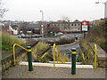
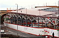
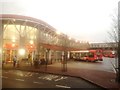
1
Mansfield NG18, Notts.
The bus parking bays at the new bus station. This £9m project was opened on time on 31st March 2013. This picture was taken on a Sunday morning, hence its emptiness. One of the bus entrances lies behind the orange-coloured Trent Barton Company bus.
Image: © David Hallam-Jones
Taken: 28 Apr 2013
0.00 miles
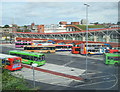
3
Mansfield Bus Station
A mixture of Stagecoach East Midland and TrentBarton vehicles use Mansfield's modern bus station.
Image: © Stephen McKay
Taken: 23 Jul 2016
0.00 miles
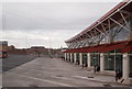
4
Mansfield, Notts (Quaker Way)
The new £13m bus station on Quaker Lane is expected to open in Spring 2013 and will bring the railway station and the bus station much nearer to each other. This is the view looking in the direction of Albert Street, through the viaduct arch. It is said that on average 55 million users are expected to pass through this bus station each year, more than the number of passengers that use East Midlands Airport in any given year.
Image: © David Hallam-Jones
Taken: 15 Jul 2012
0.01 miles
5
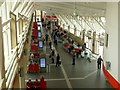
Mansfield Bus Station
The passenger concourse seen from the bridge leading to the railway station.
Image: © Alan Murray-Rust
Taken: 21 Aug 2019
0.01 miles
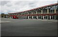
6
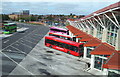
Mansfield, Notts.
The replacement bus station, off Quaker Way, seen from a new, glass-enclosed footbridge that links it to the railway station. This new bus station opened in March 2013. The bus parking bays and some of the local area are seen here from the footbridge, including the bowling alley on Rosemary Street (A6009), in the top left-hand corner of the picture, that is situated in front of a taller building on Stockwell Gate (the A38).
Image: © David Hallam-Jones
Taken: 13 Sep 2013
0.01 miles
7
Mansfield, Notts.
A view of the new (replacement) bus station, off Quaker Way, from the new, glass-enclosed footbridge that links it to the railway station. The footbridge provides views of the bus parking zone and parts of the town too. It opened in March 2013.
Image: © David Hallam-Jones
Taken: 13 Sep 2013
0.01 miles
8
Mansfield Bus Station
The re-curved facade of the bus interchange in Mansfield, pictured on a gloomy late afternoon in early January.
Image: © Jonathan Clitheroe
Taken: 10 Jan 2018
0.02 miles
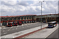
9

Mansfield Bus Station
A Stagecoach bus waits in one of the bays at Mansfield Bus Station. It is on a 210 service to Mansfield Woodhouse.
Image: © Stephen McKay
Taken: 23 Jul 2016
0.02 miles