1
Waste ground near Portland Park - 2
Looking east to the railway embankment and the bridge over Lindley's Lane. Beyond the embankment are the houses on Grives Lane at the southern end of Kirkby-in-Ashfield.
Image: © Trevor Rickard
Taken: 28 Nov 2009
0.19 miles
2
Portland Park Nature Reserve Area NG17, Notts.
A "Robin Hood Line" train heading towards Newstead, in the vicinity of the "Top Car Park" a free car park that serves the Portland Park Nature Reserve. A pedestrian has left the "Top Car Park" vicinity and is walking along Lindley's Lane. Lindley's Lane continues on the other side of the bridge in the direction of Kirkby-in-Ashfield. The 'new' houses on the other side of the railway line are situated on Sylvan Avenue.
Image: © David Hallam-Jones
Taken: 28 Feb 2013
0.20 miles
3
Portland Park Nature Reserve NG17, Notts.
Part of the newly resurfaced "Top Path". An elderly resident explained to me that when he was a boy, 75+ years ago, this was a 10 foot deep quarried area known to local lads as "The Rocks" and that during the past "xyz" years it was used as an official tip and gradually filled in, before top soil was deposited on top of it. The 6th Duke of Portland gave the whole of this 10 hectare (25 acre) site to the Urban District Council in 1914 for recreational use, to commemorate his 25th wedding anniversary and his son's 21st birthday.
Image: © David Hallam-Jones
Taken: 28 Feb 2013
0.21 miles
4
Waste ground near Portland Park
Looking south-east to the outskirts of Kirkby-in-Ashfield with the railway embankment running along the left. This area of land between the embankment and Portland Park seems to be unused. The limestone rock under foot feels like rubble and is probably not suitable for farming.
Image: © Trevor Rickard
Taken: 28 Nov 2009
0.22 miles
5
Fence by the railway
The public footpath tracks north to Kirkby-in-Ashfield alongside the railway and is separated by a modern metal fence with sharp points on the top to prevent access. The fence provides a good support for a tangle of Black Bryony, with its clusters of red berries.
Image: © Trevor Rickard
Taken: 28 Nov 2009
0.23 miles
6
Path in Portland Park
Image: © Graham Hogg
Taken: 3 May 2016
0.23 miles
7
Path in Portland Park
Looking north-west along the circular path around the country park.
Image: © Trevor Rickard
Taken: 28 Nov 2009
0.23 miles
8
Small pond in Portland Park
Pretty much the source of the River Erewash
Image: © David Lally
Taken: 3 Sep 2023
0.24 miles
9
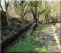
Portland Park Nature Reserve NG17, Notts
The fact that this former paddling pool is filled and emptied at either end by a stream, has allowed its conversion into a part of a small wetland area. The ponds and concrete bridges in this area of the valley floor are the only remaining features of what was an area where people used to congregate in the 30s and 40s to enjoy formal features that included a bandstand, a bowling green and a rifle range.
Image: © David Hallam-Jones
Taken: 28 Feb 2013
0.24 miles
10
Portland Park Nature Reserve NG17, Notts.
This pond, a couple of concrete bridges and a concrete paddling pool (located behind the photographer) are the only remaining features - along this stretch of the valley floor - of an area where people used to congregate during the 30s and 40s to enjoy such formal features as a bandstand, a bowling green and a rifle range. Several pools now provide a smll wetland area.
Image: © David Hallam-Jones
Taken: 28 Feb 2013
0.24 miles


