IMAGES TAKEN NEAR TO
Hornbeam Way, NOTTINGHAM, NG17 8RL
Introduction
This page details the photographs taken nearby to Hornbeam Way, NG17 8RL by members of the Geograph project.
The Geograph project started in 2005 with the aim of publishing, organising and preserving representative images for every square kilometre of Great Britain, Ireland and the Isle of Man.

There are currently over 7.5m images from over14,400 individuals and you can help contribute to the project by visiting https://www.geograph.org.uk
Image Map
Images are licensed for reuse under creativecommons.org/licenses/by-sa/2.0
Notes
- Clicking on the map will re-center to the selected point.
- The higher the marker number, the further away the image location is from the centre of the postcode.
Image Listing (10 Images Found)
Images are licensed for reuse under creativecommons.org/licenses/by-sa/2.0
Image
Details
Distance
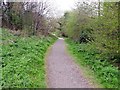
1
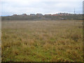
Waste ground near Portland Park - 2
Looking east to the railway embankment and the bridge over Lindley's Lane. Beyond the embankment are the houses on Grives Lane at the southern end of Kirkby-in-Ashfield.
Image: © Trevor Rickard
Taken: 28 Nov 2009
0.13 miles
2
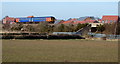
Portland Park Nature Reserve Area NG17, Notts.
A "Robin Hood Line" train heading towards Newstead, in the vicinity of the "Top Car Park" a free car park that serves the Portland Park Nature Reserve. A pedestrian has left the "Top Car Park" vicinity and is walking along Lindley's Lane. Lindley's Lane continues on the other side of the bridge in the direction of Kirkby-in-Ashfield. The 'new' houses on the other side of the railway line are situated on Sylvan Avenue.
Image: © David Hallam-Jones
Taken: 28 Feb 2013
0.13 miles
3
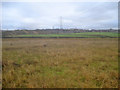
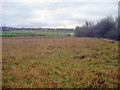
Waste ground near Portland Park
Looking south-east to the outskirts of Kirkby-in-Ashfield with the railway embankment running along the left. This area of land between the embankment and Portland Park seems to be unused. The limestone rock under foot feels like rubble and is probably not suitable for farming.
Image: © Trevor Rickard
Taken: 28 Nov 2009
0.20 miles
4
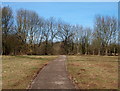
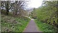
Portland Park Nature Reserve NG17, Notts.
Part of the newly resurfaced "Top Path". An elderly resident explained to me that when he was a boy, 75+ years ago, this was a 10 foot deep quarried area known to local lads as "The Rocks" and that during the past "xyz" years it was used as an official tip and gradually filled in, before top soil was deposited on top of it. The 6th Duke of Portland gave the whole of this 10 hectare (25 acre) site to the Urban District Council in 1914 for recreational use, to commemorate his 25th wedding anniversary and his son's 21st birthday.
Image: © David Hallam-Jones
Taken: 28 Feb 2013
0.22 miles
5
Waste ground near Portland Park - 3
View south towards Nuncargate. The boundary of Portland Park is on the right.
Image: © Trevor Rickard
Taken: 28 Nov 2009
0.22 miles
6
Portland Park Nature Reserve NG17, Notts.
The resurfacing of this, the "Top Car Park", seems almost complete. An elderly resident explained to me that when he was a boy, 75+ years ago, this was a 10 foot deep quarried area known to local lads as "The Rocks" and that during the past "xyz" years it was used as a tip and gradually filled in, before top soil was deposited on top of it. The 6th Duke of Portland gave the whole of this 10 hectare (25 acre) site to the Urban District Council in 1914 for recreational use, to commemorate his 25th wedding anniversary and his son's 21st birthday.
Image: © David Hallam-Jones
Taken: 28 Feb 2013
0.23 miles
7
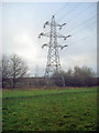
Power lines at Portland Park
From the country park looking east along the line of pylons south of Kirkby-in-Ashfield.
Image: © Trevor Rickard
Taken: 28 Nov 2009
0.23 miles
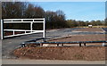
10

Portland Park Nature Reserve Area NG17, Notts.
Lindley's Lane and the Portland Park Nature Reserve lie behind the photographer. This is Grives Lane, a through-road in the past between the B6021 (Kingsway-Nottingham Road) and Lindley's Lane but now only accessible by agricultural vehicles, walkers and cyclists. A railway embankment lies to the left and the level crossing ahead gives trains on the "Robin Hood Line" (the Mansfield-Nottingham service) the right of way.
Image: © David Hallam-Jones
Taken: 28 Feb 2013
0.24 miles