IMAGES TAKEN NEAR TO
Charnwood Street, SUTTON-IN-ASHFIELD, NG17 1HR
Introduction
This page details the photographs taken nearby to Charnwood Street, NG17 1HR by members of the Geograph project.
The Geograph project started in 2005 with the aim of publishing, organising and preserving representative images for every square kilometre of Great Britain, Ireland and the Isle of Man.

There are currently over 7.5m images from over14,400 individuals and you can help contribute to the project by visiting https://www.geograph.org.uk
Image Map
Images are licensed for reuse under creativecommons.org/licenses/by-sa/2.0
Notes
- Clicking on the map will re-center to the selected point.
- The higher the marker number, the further away the image location is from the centre of the postcode.
Image Listing (18 Images Found)
Images are licensed for reuse under creativecommons.org/licenses/by-sa/2.0
Image
Details
Distance
1
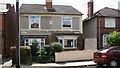
Semi-detached houses
This photograph shows a pair of semi-detached houses in Image These houses (built circa 1913) typify those on the southerly side of the south-eastern end of the street.
Image: © Alan Walker
Taken: 29 Jun 2007
0.01 miles
2
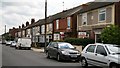
Charnwood Street
This south-easterly facing photograph of Charnwood Street (a cul-de-sac) is looking along a row of small Image built during the first two decades of the twentieth century.
Ahead, at the end of the street, is its junction with Image
At the other end of the street, behind the viewpoint, the street terminates in open land with a cycle/footpath route and a recreation ground.
For another photograph of Charnwood Street, taken from a few metres behind this viewpoint and looking straight along the roadway toward the end of the street, click here: Image
For another photograph of Charnwood Street, taken from the same viewpoint but looking in the opposite direction, click here: Image
Image: © Alan Walker
Taken: 29 Jun 2007
0.04 miles
3
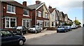
Charnwood Street
This west north-westerly facing photograph of Charnwood Street (a cul-de-sac) is looking along a row of semi-detached houses built during the first two decades of the twentieth century.
Ahead, the street terminates in open land with a cycle/footpath route and a recreation ground.
At the other end of the street, behind the viewpoint, is its junction with Image
For another photograph of Charnwood Street, taken from the same viewpoint but looking in the opposite direction, click here: Image
Image: © Alan Walker
Taken: 29 Jun 2007
0.04 miles
4
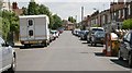
Charnwood Street
This east south-easterly facing photograph of Charnwood Street (a cul-de-sac) is looking toward its junction with Image
Behind the viewpoint, the street terminates in open land with a cycle/footpath route and a recreation ground.
The roadway is reasonably wide for one of the period but the parked cars show the problem associated with housing built before the owning of motor vehicles became pluralistic and commonplace.
For another photograph of Charnwood Street, taken from a few metres ahead, but looking more toward the houses on the right of this picture, click here: Image
For another photograph of Charnwood Street, taken from a few metres ahead, but looking back, beyond this viewpoint, click here: Image
Image: © Alan Walker
Taken: 29 Jun 2007
0.06 miles
5
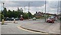
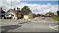
Alfreton Road
This south south-westerly facing photograph of Alfreton Road was taken from its junction with Image (immediate foreground).
Ahead and on the left the motor vehicles are parked outside a building containing an estate agents, a hair salon and a Image
Beyond the roundabout Alfreton Road continues in a south-westerly direction toward its junction with the A38.
For another photograph of the same scene but taken from the pedestrian refuge on the middle left of the picture, click here Image
For another photograph, taken from the same junction but facing the opposite direction, click here Image
Image: © Alan Walker
Taken: 29 Jun 2007
0.08 miles
7
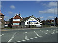
Sutton-in-Ashfield - Mapplewells Inn
On Alfreton Road.
Image: © Dave Bevis
Taken: 14 Apr 2015
0.08 miles
8
Mapplewells Inn
Image: © Alan Walker
Taken: 29 Jun 2007
0.09 miles
9
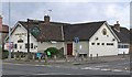
Nursery Avenue
This north-westerly facing photograph shows the junction of Nursery Avenue (ahead) with Image (foreground).
The low, cream building on the left is the Image
Image: © Alan Walker
Taken: 29 Jun 2007
0.09 miles
10
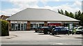
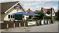
Convenience Store
This convenience store, which shares a building with an estate agents and a hair salon, is located on Image near the roundabout junction with Woodlands Way and Frederic Street.
Image: © Alan Walker
Taken: 29 Jun 2007
0.09 miles