IMAGES TAKEN NEAR TO
Alexander Terrace, NOTTINGHAM, NG16 6PL
Introduction
This page details the photographs taken nearby to Alexander Terrace, NG16 6PL by members of the Geograph project.
The Geograph project started in 2005 with the aim of publishing, organising and preserving representative images for every square kilometre of Great Britain, Ireland and the Isle of Man.

There are currently over 7.5m images from over14,400 individuals and you can help contribute to the project by visiting https://www.geograph.org.uk
Image Map
Images are licensed for reuse under creativecommons.org/licenses/by-sa/2.0
Notes
- Clicking on the map will re-center to the selected point.
- The higher the marker number, the further away the image location is from the centre of the postcode.
Image Listing (23 Images Found)
Images are licensed for reuse under creativecommons.org/licenses/by-sa/2.0
Image
Details
Distance
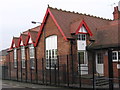
2
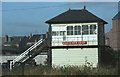
Pinxton - Sleights East Signal Box
A Midland Railway signal box erected in 1892. It closed in June 2007, when the line was resignalled, and was subsequently moved to the nearby car dismantlers yard. It was then bought and moved in early 2008 by the Embsay and Bolton Abbey Railway in Yorkshire to their Bolton Abbey station. It is being restored to allow the public to see how manual signal boxes worked - see Image
Image: © Dave Bevis
Taken: 1 May 1984
0.04 miles
3
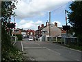
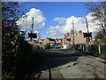
Sleights East level crossing
Where Pinxton's Alexander Terrace crosses the railway line from Pye Bridge junction to Kirkby in Ashfield.
Image: © Christine Johnstone
Taken: 19 Aug 2017
0.05 miles
4
Level Crossing, Alexander Terrace, Pinxton
Image: © Jonathan Thacker
Taken: 17 Mar 2023
0.05 miles
5
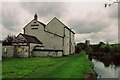
Pinxton Wharf
Not just another pub geograph! Pinxton Wharf is the northern terminus of the Cromford Canal http://www.cromfordcanal.org.uk/ , which opened up local coalfields and Pinxton porcelain to a wide market via the Erewash Canal. From here, an early railway (the Mansfield and Pinxton) was opened in 1819 to connect Mansfield with the canal system. Tickets to travel on the horse drawn line could be bought at the Boat Inn.
Image: © Nick Leverton
Taken: Unknown
0.05 miles
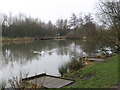
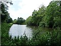
6
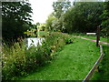
North bank, Pinxton Wharf
The terminus of the Pinxton Arm of the Cromford Canal. Once a narrow wharf lined with railway tracks, gas works and lime kilns, it has now been widened out into a pleasant pool, popular with anglers and walkers alike.
Image: © Christine Johnstone
Taken: 19 Aug 2017
0.07 miles
7
Pinxton Wharf
The head of the Pinxton Canal. Now a public park.
Image: © Jonathan Thacker
Taken: 17 Mar 2023
0.08 miles
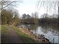
8
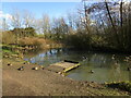
South side of Pinxton Wharf, from the east
This is the original part of the wharf, before the pool was extended. The terminus of the Pinxton Arm of the Cromford Canal.
Image: © Christine Johnstone
Taken: 19 Aug 2017
0.09 miles
9
Pinxton Wharf
Looking towards the terminus of the Pinxton Arm of the Cromford Canal, originally a 3 mile stretch of water which was used to transport Pinxton Porcelain. It has long fallen into disuse but in keeping with the renewed interest in Britain's lost waterways, plans are afoot to restore this whole section.
Image: © Jonathan Clitheroe
Taken: 16 Feb 2013
0.09 miles