IMAGES TAKEN NEAR TO
Bourne Avenue, NOTTINGHAM, NG16 6BH
Introduction
This page details the photographs taken nearby to Bourne Avenue, NG16 6BH by members of the Geograph project.
The Geograph project started in 2005 with the aim of publishing, organising and preserving representative images for every square kilometre of Great Britain, Ireland and the Isle of Man.

There are currently over 7.5m images from over14,400 individuals and you can help contribute to the project by visiting https://www.geograph.org.uk
Image Map
Images are licensed for reuse under creativecommons.org/licenses/by-sa/2.0
Notes
- Clicking on the map will re-center to the selected point.
- The higher the marker number, the further away the image location is from the centre of the postcode.
Image Listing (25 Images Found)
Images are licensed for reuse under creativecommons.org/licenses/by-sa/2.0
Image
Details
Distance
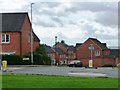
1
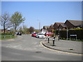
South end of Bourne Avenue, Selston
Seen from Portland Road.
Image: © Richard Vince
Taken: 21 Apr 2018
0.04 miles
2
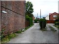
Chapel Street, off Portland Road
The track to the left [north] is Chapel Street. The track to the right [south] provides access to the back of houses on Portland Road.
Image: © Christine Johnstone
Taken: 19 Aug 2017
0.05 miles
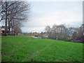
3

Open space on the east side of Portland Road
Maintained by the parish council. This is not the site of recently demolished buildings, as the same open space is clearly shown on OS maps from the 1880s.
Image: © Christine Johnstone
Taken: 19 Aug 2017
0.06 miles
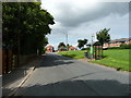
4
Portland Road
Looking south-east from the junction with Mansfield Road. A wide grassy bank runs the length of this road.
Image: © Trevor Rickard
Taken: 28 Nov 2009
0.07 miles
5
Flags flying at Portland Road post office
Two on the wall and one in the window.
Image: © Christine Johnstone
Taken: 19 Aug 2017
0.08 miles
6
Pippin Close, off Portland Road
A newish infill estate, dropping down the hillside.
Image: © Christine Johnstone
Taken: 19 Aug 2017
0.09 miles
7
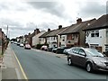
Houses on the west side of Portland Road
When mapped in 1951, this area was called New Portland. It now seems to have morphed into Selston.
Image: © Christine Johnstone
Taken: 19 Aug 2017
0.09 miles
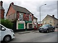
8
Bus stops on Portland Road
Looking north-west to Mansfield Road.
Image: © Christine Johnstone
Taken: 19 Aug 2017
0.13 miles
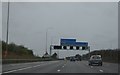
10
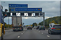
Ashfield : M1 Motorway
The M1 Motorway between Junction 28 and Junction 27.
Image: © Lewis Clarke
Taken: 3 Oct 2018
0.16 miles