IMAGES TAKEN NEAR TO
Codnor Park, Ironville, NOTTINGHAM, NG16 5PD
Introduction
This page details the photographs taken nearby to NG16 5PD by members of the Geograph project.
The Geograph project started in 2005 with the aim of publishing, organising and preserving representative images for every square kilometre of Great Britain, Ireland and the Isle of Man.

There are currently over 7.5m images from over14,400 individuals and you can help contribute to the project by visiting https://www.geograph.org.uk
Image Map
Images are licensed for reuse under creativecommons.org/licenses/by-sa/2.0
Notes
- Clicking on the map will re-center to the selected point.
- The higher the marker number, the further away the image location is from the centre of the postcode.
Image Listing (70 Images Found)
Images are licensed for reuse under creativecommons.org/licenses/by-sa/2.0
Image
Details
Distance
3
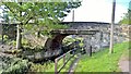
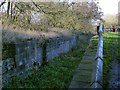
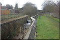
Cinder Bank road and pedestrian bridges, Ironville
Cinder Bank road and pedestrian bridges at Ironville, Derbyshire. Taken from the towpath of the disused Cromford Canal.
Image: © Martin Froggatt
Taken: 1 Jan 2020
0.03 miles
4
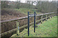
Site of Boat Dock Lock, #2 on the Cromford Canal
This section of the canal is unwatered. The Friends of Cromford Canal have ambitions to see the canal restored. http://www.cromfordcanal.info/
Image: © Graham Hogg
Taken: 9 May 2016
0.04 miles
5
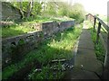
Boat Dock Lock, No.2, Cromford Canal
Part of the Codnor Park flight of locks. Although some of the locks are listed, this one is not.
Image: © Alan Murray-Rust
Taken: 30 Nov 2018
0.04 miles
6
Boat Dock Lock, Cromford Canal
Boat Dock Lock was no 2 in the Codnor Park flight of seven locks.
Image: © Stephen McKay
Taken: 26 Dec 2012
0.05 miles
8
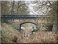
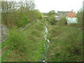
It's been reedy and waiting for a long time
There is a plan afoot to restore the Cromford Canal, which linked that Derbyshire village with the Erewash Canal and thence the River Trent and ultimately the whole wide world via the Humber, Thames, Severn or Mersey estuaries. In 1904 it could be written that the canal was "not much used" and "in indifferent condition"; a century later, as suggested by this view from Cinder Bank bridge in Ironville, those statements still hold true.
Image: © A-M-Jervis
Taken: 7 Sep 2005
0.07 miles
9
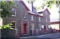
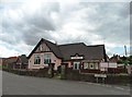
Doctor's house, Ironville
Built as a doctor's house by the local mineowner, the building is made of iron slag. Currently being converted to apartments. The first doctor appointed (who was due to marry the mineowner's daughter) was killed in an accident.
Image: © S Parish
Taken: 24 Aug 2006
0.07 miles
10
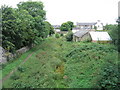
Pottery Lock, Cromford Canal
Pottery Lock, by Adelaide Walk, was no 3 in the Codnor Park flight of seven locks. There is a flow of water here from Codnor Park Reservoir to the River Erewash.
Image: © Stephen McKay
Taken: 26 Dec 2012
0.07 miles