IMAGES TAKEN NEAR TO
The Park, NOTTINGHAM, NG16 5PB
Introduction
This page details the photographs taken nearby to The Park, NG16 5PB by members of the Geograph project.
The Geograph project started in 2005 with the aim of publishing, organising and preserving representative images for every square kilometre of Great Britain, Ireland and the Isle of Man.

There are currently over 7.5m images from over14,400 individuals and you can help contribute to the project by visiting https://www.geograph.org.uk
Image Map
Images are licensed for reuse under creativecommons.org/licenses/by-sa/2.0
Notes
- Clicking on the map will re-center to the selected point.
- The higher the marker number, the further away the image location is from the centre of the postcode.
Image Listing (31 Images Found)
Images are licensed for reuse under creativecommons.org/licenses/by-sa/2.0
Image
Details
Distance
1
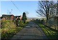
Monument Lane, Codnor Park
This part of the lane is a private road, but is designated as a public bridleway, although not marked as such on current OS maps.
Image: © Alan Murray-Rust
Taken: 30 Nov 2018
0.04 miles
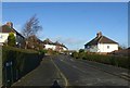
2
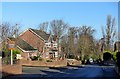
Monument Lane, Codnor Park
The top of Codnor Park residential area, developed largely between the wars, but with later housing too.
Image: © Alan Murray-Rust
Taken: 30 Nov 2018
0.07 miles
3
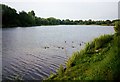
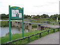
Codnor Park Reservoir, Ironville
A feeder for the Cromford canal, this is a pleasant spot for walking and fishing, with good access for disabled anglers.
Image: © Lynne Kirton
Taken: Unknown
0.14 miles
4
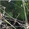
Bench mark, Station Lane, Codnor Park
On a field gatepost opposite the end of New Road.
Image: © Alan Murray-Rust
Taken: 30 Nov 2018
0.17 miles
5
New Road, Codnor Park
Part of the inter-war expansion of housing in the area.
Image: © Alan Murray-Rust
Taken: 30 Nov 2018
0.18 miles
7
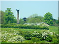
Jessops Monument and Monument Hall (Codnor Park)
Image: © Rob Howl
Taken: 24 May 2012
0.20 miles
8
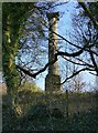
Jessop Monument, Codnor Park
Built as a viewing platform in 1858, it would have given fine views of the various industrial sites of the Butterley Company. William Jessop was one of the founders of the Butterley Company.
The area in which it stands was dedicated as a park for the Company's employees but is now private land. The monument is only photographable from Monument Lane during the winter months. Listed Grade II.
Image: © Alan Murray-Rust
Taken: 30 Nov 2018
0.20 miles
9
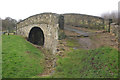
Pinxton Arm bridge, Codnor Park
This bridge is a reminder of the long-disused 3-mile long Pinxton canal arm that left the Cromford Canal main line here, next to Codnor Park Reservoir.
Image: © Stephen McKay
Taken: 26 Dec 2012
0.20 miles
10
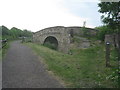
Bridge over the Pinxton Canal
The Pinxton Canal has long been closed and infilled. This bridge is one of the few reminders of its existence and is situatted close to where the canal joined the Cromford Canal.
Image: © Jonathan Thacker
Taken: 30 May 2012
0.20 miles