IMAGES TAKEN NEAR TO
Victoria Street, NOTTINGHAM, NG16 5NB
Introduction
This page details the photographs taken nearby to Victoria Street, NG16 5NB by members of the Geograph project.
The Geograph project started in 2005 with the aim of publishing, organising and preserving representative images for every square kilometre of Great Britain, Ireland and the Isle of Man.

There are currently over 7.5m images from over14,400 individuals and you can help contribute to the project by visiting https://www.geograph.org.uk
Image Map
Images are licensed for reuse under creativecommons.org/licenses/by-sa/2.0
Notes
- Clicking on the map will re-center to the selected point.
- The higher the marker number, the further away the image location is from the centre of the postcode.
Image Listing (60 Images Found)
Images are licensed for reuse under creativecommons.org/licenses/by-sa/2.0
Image
Details
Distance
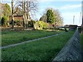
1
Bed of the Pinxton Canal
Developed as a greenway footpath. Seen from the bridge on Bullock Lane.
Image: © Alan Murray-Rust
Taken: 30 Nov 2018
0.03 miles
2
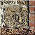
Bench mark, former canal bridge, Ironville
See http://www.geograph.org.uk/photo/5991777 for location.
Image: © Alan Murray-Rust
Taken: 30 Nov 2018
0.06 miles
3
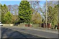
Former canal bridge over the Pinxton Canal, Ironville
On the main road to Riddings. There is a benchmark http://www.geograph.org.uk/photo/5991776 on the stone wall to the left of the brick parapet.
Image: © Alan Murray-Rust
Taken: 30 Nov 2018
0.06 miles
4
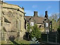
Parson's Cottage, Ironville
Formerly The Poplars, built c.1850 in Tudor Revival style, Listed Grade II. Despite the current name, it doesn't appear to have been connected with the church. The Vicarage was a different building.
There is a benchmark http://www.geograph.org.uk/photo/5991771 on the right hand buttress of the church.
Image: © Alan Murray-Rust
Taken: 30 Nov 2018
0.07 miles
5
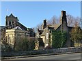
Parson's Cottage and Christ Church, Ironville
Developed as a greenway footpath. Seen from the bridge on Bullock Lane.
Image: © Alan Murray-Rust
Taken: 30 Nov 2018
0.08 miles
7
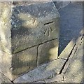
Bench mark, Christ Church, Ironville
See http://www.geograph.org.uk/photo/5991772 for location.
Image: © Alan Murray-Rust
Taken: 30 Nov 2018
0.08 miles
8
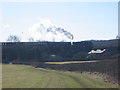
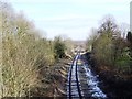
Ironville Junction on the Midland Railway
The preserved Midland Railway runs from Butterley to the junction with the main line at Ironville as seen here. Caprotti Black 5 73129 powers away to head back to the main museum site at Swanwick on a frosty and bright March morning.
Image: © Mike Bardill
Taken: 5 Mar 2006
0.08 miles
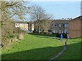
9
Bed of the Pinxton Canal
At the back of the churchyard, now hosting a public footpath.
Image: © Alan Murray-Rust
Taken: 30 Nov 2018
0.08 miles