IMAGES TAKEN NEAR TO
Meadow Street, NOTTINGHAM, NG16 5NA
Introduction
This page details the photographs taken nearby to Meadow Street, NG16 5NA by members of the Geograph project.
The Geograph project started in 2005 with the aim of publishing, organising and preserving representative images for every square kilometre of Great Britain, Ireland and the Isle of Man.

There are currently over 7.5m images from over14,400 individuals and you can help contribute to the project by visiting https://www.geograph.org.uk
Image Map
Images are licensed for reuse under creativecommons.org/licenses/by-sa/2.0
Notes
- Clicking on the map will re-center to the selected point.
- The higher the marker number, the further away the image location is from the centre of the postcode.
Image Listing (50 Images Found)
Images are licensed for reuse under creativecommons.org/licenses/by-sa/2.0
Image
Details
Distance
1
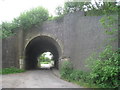
Railway bridges near Ironville (3)
This carries the Codnor Park Junction to Swanwick Colliery line of the Midland railway (opened in 1874) over Nottingham Lane. The line was extended a year later to Crich Junction and is now part of the preserved Midland Railway Centre.
Image: © Jonathan Thacker
Taken: 30 May 2012
0.04 miles
2
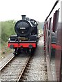
Midland Railway Centre, near Ironville
Train ride - S&DJR Class 7F 53809 runs around its train. Next stop is Swanwick Junction.
Image: © Dave Hitchborne
Taken: 12 Apr 2009
0.07 miles
3
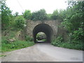
Railway bridges near Ironville (4)
This carries a spur from the Codnor Park Junction to Crich Junction line to the Nottingham to Sheffield main line of the Midland Railway between Ironville Junction and Riddings Junction where it crosses Nottingham Lane. It was opened in 1875 and now forms part of the Midland Railway Centre.
Image: © Jonathan Thacker
Taken: 30 May 2012
0.07 miles
4
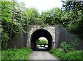
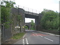
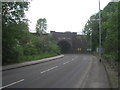
Railway bridge, Nottingham Road, Ironville
Image: © Neil Theasby
Taken: 23 May 2016
0.07 miles
5
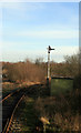
Ironville Junction on the Midland Railway
The preserved Midland Railway runs from Butterley to the junction with the main line at Ironville as seen here. Caprotti Black 5 73129 powers away to head back to the main museum site at Swanwick on a frosty and bright March morning.
Image: © Mike Bardill
Taken: 5 Mar 2006
0.08 miles
6
Midland Railway Centre - link to mainline
This single track spur links the Midland Railway centre to the national rail network.
Image: © Chris Allen
Taken: 16 Jan 2016
0.08 miles
7
Railway bridges near Ironville (2)
This carries the Codnor Park Junction to Swanwick Colliery line of the Midland railway (opened in 1874) over the B6016. The line was extended a year later to Crich Junction and is now part of the preserved Midland Railway Centre.
Image: © Jonathan Thacker
Taken: 30 May 2012
0.09 miles
8
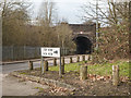
Pye Hill Road Railway Bridge
Pye Hill Road Railway bridge Nottinghamshire. Street furniture, transport, industry.
Image: © Martin Froggatt
Taken: 4 Jan 2020
0.11 miles
9
Railway bridges near Ironville (1)
This carries the main Nottingham to Sheffield line (opened in 1850 by the Midland Railway) over the B6016.
Image: © Jonathan Thacker
Taken: 30 May 2012
0.12 miles
10
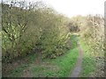
The former Pinxton Arm, the Cromford Canal
Looking north from the railway line at Ironville. This branch of the Cromford Canal runs 3 miles from the northerly end of the Codnor Reservoir to the wharf at Pinxton. It is now almost completely filled in, but the Friends of the Cromford Canal hope to restore it to navigation.
Image: © Christine Johnstone
Taken: 31 Oct 2014
0.13 miles