IMAGES TAKEN NEAR TO
St. Marys Walk, NOTTINGHAM, NG16 5LN
Introduction
This page details the photographs taken nearby to St. Marys Walk, NG16 5LN by members of the Geograph project.
The Geograph project started in 2005 with the aim of publishing, organising and preserving representative images for every square kilometre of Great Britain, Ireland and the Isle of Man.

There are currently over 7.5m images from over14,400 individuals and you can help contribute to the project by visiting https://www.geograph.org.uk
Image Map
Images are licensed for reuse under creativecommons.org/licenses/by-sa/2.0
Notes
- Clicking on the map will re-center to the selected point.
- The higher the marker number, the further away the image location is from the centre of the postcode.
Image Listing (28 Images Found)
Images are licensed for reuse under creativecommons.org/licenses/by-sa/2.0
Image
Details
Distance
1
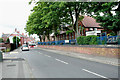
Main Road, Jacksdale
Former mining village on the Notts. / Derbys. border.
Image: © David Lally
Taken: 31 Jul 2010
0.03 miles
2
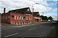
The Dale Club
Miners Welfare Club in Jacksdale. I have not been able to find out exactly when the local collieries closed, but Pye Hill was still working in 1986.
Image: © David Lally
Taken: 31 Jul 2010
0.04 miles
3
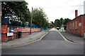
Church Hill
I think I'm in Jacksdale, but the church which is a couple of hundred yards up the hill is referred to as St Mary's, Westwood. All very confusing.
Image: © David Lally
Taken: 31 Jul 2010
0.07 miles
5
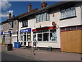
Jacksdale: the post office
The position of the postbox - in the wall of the shop next door - suggests perhaps that the post office was once larger, occupying both frontages. This would appear to be supported by the large-scale mapping, which appears to mark 'PO' across a larger area than just this right-hand shop.
Image: © Chris Downer
Taken: 26 Apr 2013
0.10 miles
6
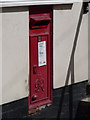
Jacksdale: postbox № NG16 309, Main Road
This George VI-reign postbox is set into the wall of Image - in fact, in the wall of the shop next door, perhaps suggesting that the post office once occupied both premises.
Image: © Chris Downer
Taken: 26 Apr 2013
0.10 miles
7
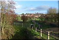
Site of Portland Wharf
Originally a large basin on the Cromford Canal acting as a transshipment point for coal brought down on tramroads from the Portland and associated collieries in the Selston area. It stretched as far as the houses of Jacksdale in the background.
The footpath provides access from Jacksdale to the footpaths along the canal and to the Erewash Meadows Nature Reserve, but was originally a means of access to employment at the Codnor Park Ironworks.
Image: © Alan Murray-Rust
Taken: 30 Nov 2018
0.11 miles
9
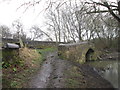
Bridge over the entrance to the basin at Jacksdale
Jack's Dale on some old maps
Image: © John Slater
Taken: 5 Mar 2017
0.12 miles
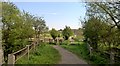
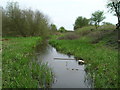
10
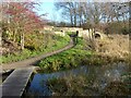
Cromford Canal near Jacksdale
The modern timber bridge forms part of the network of public footpaths established on the former Codnorpark ironworks, now part of the Erewash Meadows Nature Reserve. The stone bridge carried the towpath over the branch of the canal forming Portland Wharf, originally a transfer point with the tramroad serving collieries to the east of the Erewash valley.
Image: © Alan Murray-Rust
Taken: 30 Nov 2018
0.13 miles