IMAGES TAKEN NEAR TO
Stoney Lane, NOTTINGHAM, NG16 5AL
Introduction
This page details the photographs taken nearby to Stoney Lane, NG16 5AL by members of the Geograph project.
The Geograph project started in 2005 with the aim of publishing, organising and preserving representative images for every square kilometre of Great Britain, Ireland and the Isle of Man.

There are currently over 7.5m images from over14,400 individuals and you can help contribute to the project by visiting https://www.geograph.org.uk
Image Map
Images are licensed for reuse under creativecommons.org/licenses/by-sa/2.0
Notes
- Clicking on the map will re-center to the selected point.
- The higher the marker number, the further away the image location is from the centre of the postcode.
Image Listing (13 Images Found)
Images are licensed for reuse under creativecommons.org/licenses/by-sa/2.0
Image
Details
Distance
1
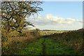
Bridleway near Brinsley
This follows a remarkably zig-zag route along the side of the former Moorgreen Colliery spoil tip.
Image: © Alan Murray-Rust
Taken: 12 Nov 2018
0.16 miles
2
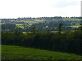
Behind Dirt Hill
Taken from the Bridleway leading around the back of Dirt Hill.
Image: © Chris Page
Taken: 17 Aug 2009
0.17 miles
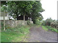
4
Hall Lane, Brinsley, Nottinghamshire
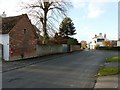
Brinsley is a former mining village. Although still surrounded by productive farmland, nowadays it is more a commuter village for Nottingham and other local towns. Hall Lane is within the conservation area of what local people know as 'Old Brinsley'. New Brinsley is a kilometre or so to the north, although both settlements are continuous with each other. Stoney Lane is the left turn by the yellow grit bin and is a 'dead end'. Hall Lane is another 'dead end' that eventually leads to Hall Farm. The White Lion is one of six public houses in Brinsley and New Brinsley.
Image: © Alan Slater
Taken: 26 Jun 2006
0.21 miles
5
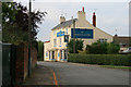
Hall Lane, Brinsley
Victorian postbox http://www.geograph.org.uk/photo/5976034 in the building on the left, the old White Lion pub in the distance.
Image: © Alan Murray-Rust
Taken: 12 Nov 2018
0.22 miles
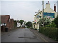
6
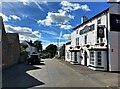
Public House on Hall Lane in Brinsley
A warm welcome was proffered in The Lion on this warm July afternoon.
Image: © Jonathan Clitheroe
Taken: 5 Jul 2022
0.22 miles
7
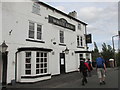
The White Lion public house.
Almost back to the car on a walk from Brinsley.
Image: © steven ruffles
Taken: 13 Oct 2018
0.22 miles
9
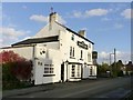
The old White Lion, Brinsley
Now trading as The Lion at Brinsley, a specialised restaurant rather than a pub.
Image: © Alan Murray-Rust
Taken: 12 Nov 2018
0.22 miles
10
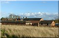
Manor Farm, Brinsley
Victorian farmstead, clearly built as a single development. A feature is the use of decorative polychrome brickwork. The farm outbuildings appear to have been converted for residential use
Image: © Alan Murray-Rust
Taken: 12 Nov 2018
0.23 miles