IMAGES TAKEN NEAR TO
High Park Cottages, NOTTINGHAM, NG16 3QZ
Introduction
This page details the photographs taken nearby to High Park Cottages, NG16 3QZ by members of the Geograph project.
The Geograph project started in 2005 with the aim of publishing, organising and preserving representative images for every square kilometre of Great Britain, Ireland and the Isle of Man.

There are currently over 7.5m images from over14,400 individuals and you can help contribute to the project by visiting https://www.geograph.org.uk
Image Map
Images are licensed for reuse under creativecommons.org/licenses/by-sa/2.0
Notes
- Clicking on the map will re-center to the selected point.
- The higher the marker number, the further away the image location is from the centre of the postcode.
Image Listing (11 Images Found)
Images are licensed for reuse under creativecommons.org/licenses/by-sa/2.0
Image
Details
Distance
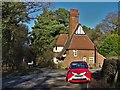
2
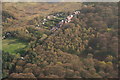
High Park Cottages
Probably built as miners' cottages for High Park Colliery which was immediately to the right of the cottages. The colliery worked until 1950 when it was merged with Moorgreen.
Image: © Alan Murray-Rust
Taken: 12 Nov 2018
0.04 miles
3
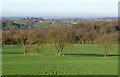
Landscape near Beauvale Priory
There is now no sign that the trees at the bottom of the field conceal the site of an old colliery.
Image: © Alan Murray-Rust
Taken: 30 Nov 2014
0.13 miles
4
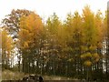
Autumn larches in Beauvale woods
The only deciduous European conifer puts on a fine golden show in autumn.
Image: © Alan Murray-Rust
Taken: 12 Nov 2018
0.16 miles
5
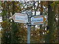
Broxtowe Country Trail fingerpost
Described as “a long distance trail which roughly follows the boundary between Broxtowe Borough and Nottingham City”, here it is well away from Nottingham City, and close to Ashfield District. For more information see https://www.broxtowe.gov.uk/media/1850/broxtowe-country-trail-guide-leaflet.pdf.
See http://www.geograph.org.uk/photo/5975320 for location.
Image: © Alan Murray-Rust
Taken: 12 Nov 2018
0.16 miles
6
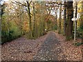
Broxtowe Country Trail in Beauvale woods
The trail divides here from the private drive to Beauvale House.
Image: © Alan Murray-Rust
Taken: 12 Nov 2018
0.17 miles
8
Path by Moorgreen reservoir
This public footpath runs through High Park Wood, mixed deciduous and coniferous woodland. The reservoir is to the left of the picture. The land to the right is private.
Image: © Lynne Kirton
Taken: 14 Jan 2007
0.20 miles
9
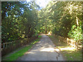
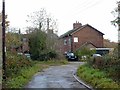
Entrance to Beauvale House
Private road heading north-east through High Park Wood. The public bridleway bears left just ahead.
Image: © Trevor Rickard
Taken: 10 Sep 2009
0.21 miles
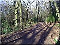
10
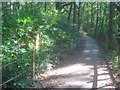
Public Bridleway through High Park Wood
Heading south through an understorey of rhododendrons.
Image: © Trevor Rickard
Taken: 10 Sep 2009
0.25 miles